You are here: Home > Network List > TA - USArray Transportable Network (new EarthScope stations) Stations List
> Station D27M Malcolm River, YT, CAN > Earthquake Result Viewer
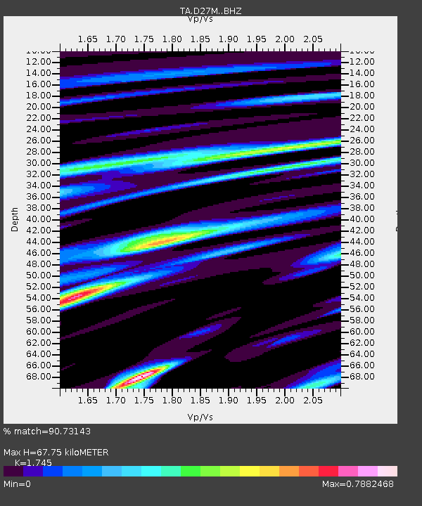
D27M Malcolm River, YT, CAN - Earthquake Result Viewer
| Earthquake location: |
Off East Coast Of Honshu, Japan |
| Earthquake latitude/longitude: |
37.5/144.0 |
| Earthquake time(UTC): |
2017/10/06 (279) 07:59:33 GMT |
| Earthquake Depth: |
10 km |
| Earthquake Magnitude: |
6.0 Mww |
| Earthquake Catalog/Contributor: |
NEIC PDE/us |
|
| Network: |
TA USArray Transportable Network (new EarthScope stations) |
| Station: |
D27M Malcolm River, YT, CAN |
| Lat/Lon: |
69.24 N/140.96 W |
| Elevation: |
896 m |
|
| Distance: |
50.3 deg |
| Az: |
26.61 deg |
| Baz: |
271.84 deg |
| Ray Param: |
0.06817005 |
| Estimated Moho Depth: |
67.75 km |
| Estimated Crust Vp/Vs: |
1.75 |
| Assumed Crust Vp: |
6.522 km/s |
| Estimated Crust Vs: |
3.737 km/s |
| Estimated Crust Poisson's Ratio: |
0.26 |
|
| Radial Match: |
90.73143 % |
| Radial Bump: |
382 |
| Transverse Match: |
78.872604 % |
| Transverse Bump: |
400 |
| SOD ConfigId: |
13570011 |
| Insert Time: |
2019-04-28 22:42:17.844 +0000 |
| GWidth: |
2.5 |
| Max Bumps: |
400 |
| Tol: |
0.001 |
|

Signal To Noise
| Channel | StoN | STA | LTA |
| TA:D27M: :BHZ:20171006T08:07:58.175002Z | 11.059676 | 1.6534948E-6 | 1.4950662E-7 |
| TA:D27M: :BHN:20171006T08:07:58.175002Z | 1.6852201 | 3.3160592E-7 | 1.9677306E-7 |
| TA:D27M: :BHE:20171006T08:07:58.175002Z | 4.858892 | 8.6954617E-7 | 1.7895975E-7 |
| Arrivals |
| Ps | 8.2 SECOND |
| PpPs | 27 SECOND |
| PsPs/PpSs | 35 SECOND |


