You are here: Home > Network List > TA - USArray Transportable Network (new EarthScope stations) Stations List
> Station F20K Avaraart Lake, AK, USA > Earthquake Result Viewer
F20K Avaraart Lake, AK, USA - Earthquake Result Viewer
| Earthquake location: |
Off East Coast Of Honshu, Japan |
| Earthquake latitude/longitude: |
37.5/144.0 |
| Earthquake time(UTC): |
2017/10/06 (279) 07:59:33 GMT |
| Earthquake Depth: |
10 km |
| Earthquake Magnitude: |
6.0 Mww |
| Earthquake Catalog/Contributor: |
NEIC PDE/us |
|
| Network: |
TA USArray Transportable Network (new EarthScope stations) |
| Station: |
F20K Avaraart Lake, AK, USA |
| Lat/Lon: |
67.05 N/155.73 W |
| Elevation: |
136 m |
|
| Distance: |
44.6 deg |
| Az: |
29.024 deg |
| Baz: |
259.775 deg |
| Ray Param: |
0.07181057 |
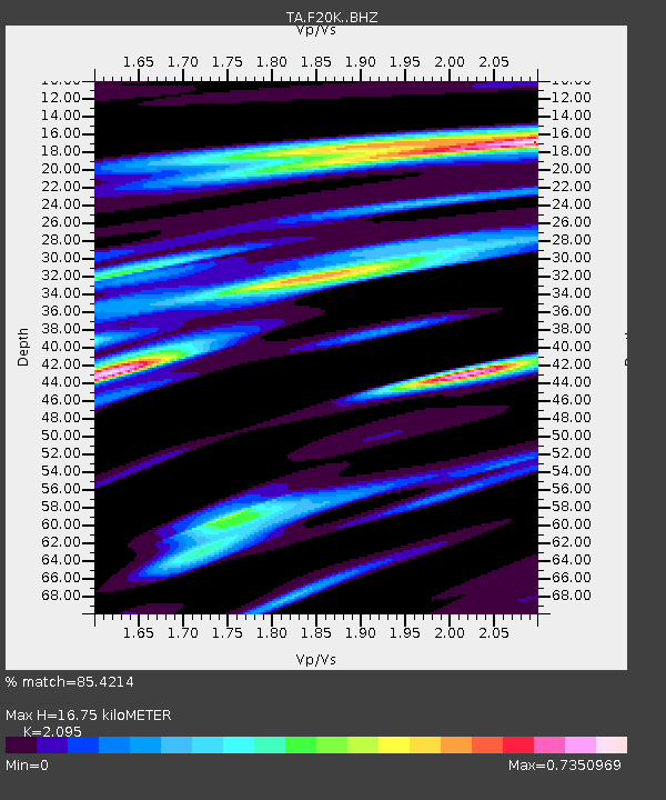
| Estimated Moho Depth: |
16.75 km |
| Estimated Crust Vp/Vs: |
2.10 |
| Assumed Crust Vp: |
6.522 km/s |
| Estimated Crust Vs: |
3.113 km/s |
| Estimated Crust Poisson's Ratio: |
0.35 |
|
| Radial Match: |
85.4214 % |
| Radial Bump: |
400 |
| Transverse Match: |
56.796913 % |
| Transverse Bump: |
400 |
| SOD ConfigId: |
13570011 |
| Insert Time: |
2019-04-28 22:42:32.215 +0000 |
| GWidth: |
2.5 |
| Max Bumps: |
400 |
| Tol: |
0.001 |
|

Signal To Noise
| Channel | StoN | STA | LTA |
| TA:F20K: :BHZ:20171006T08:07:14.175002Z | 7.9865475 | 2.2068723E-6 | 2.763237E-7 |
| TA:F20K: :BHN:20171006T08:07:14.175002Z | 1.4134772 | 4.9194927E-7 | 3.4804188E-7 |
| TA:F20K: :BHE:20171006T08:07:14.175002Z | 6.5145874 | 1.5396214E-6 | 2.3633444E-7 |
| Arrivals |
| Ps | 3.0 SECOND |
| PpPs | 7.5 SECOND |
| PsPs/PpSs | 10 SECOND |


