You are here: Home > Network List > TA - USArray Transportable Network (new EarthScope stations) Stations List
> Station G31M Satah River, YT, CAN > Earthquake Result Viewer
G31M Satah River, YT, CAN - Earthquake Result Viewer
| Earthquake location: |
Off East Coast Of Honshu, Japan |
| Earthquake latitude/longitude: |
37.5/144.0 |
| Earthquake time(UTC): |
2017/10/06 (279) 07:59:33 GMT |
| Earthquake Depth: |
10 km |
| Earthquake Magnitude: |
6.0 Mww |
| Earthquake Catalog/Contributor: |
NEIC PDE/us |
|
| Network: |
TA USArray Transportable Network (new EarthScope stations) |
| Station: |
G31M Satah River, YT, CAN |
| Lat/Lon: |
66.92 N/134.27 W |
| Elevation: |
61 m |
|
| Distance: |
53.0 deg |
| Az: |
29.242 deg |
| Baz: |
279.68 deg |
| Ray Param: |
0.0663914 |
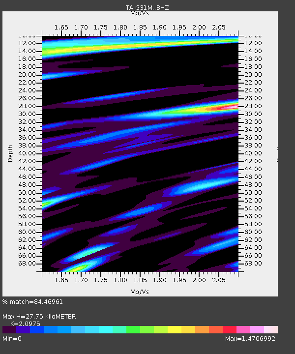
| Estimated Moho Depth: |
27.75 km |
| Estimated Crust Vp/Vs: |
2.10 |
| Assumed Crust Vp: |
6.171 km/s |
| Estimated Crust Vs: |
2.942 km/s |
| Estimated Crust Poisson's Ratio: |
0.35 |
|
| Radial Match: |
84.46961 % |
| Radial Bump: |
378 |
| Transverse Match: |
67.888596 % |
| Transverse Bump: |
400 |
| SOD ConfigId: |
13570011 |
| Insert Time: |
2019-04-28 22:42:49.862 +0000 |
| GWidth: |
2.5 |
| Max Bumps: |
400 |
| Tol: |
0.001 |
|
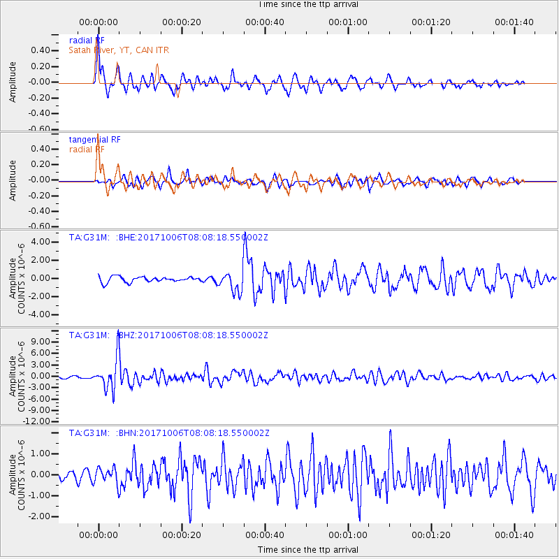
Signal To Noise
| Channel | StoN | STA | LTA |
| TA:G31M: :BHZ:20171006T08:08:18.550002Z | 17.500538 | 4.2652796E-6 | 2.4372275E-7 |
| TA:G31M: :BHN:20171006T08:08:18.550002Z | 0.72951293 | 3.5605768E-7 | 4.880759E-7 |
| TA:G31M: :BHE:20171006T08:08:18.550002Z | 5.290803 | 1.564213E-6 | 2.9564757E-7 |
| Arrivals |
| Ps | 5.1 SECOND |
| PpPs | 13 SECOND |
| PsPs/PpSs | 18 SECOND |


