You are here: Home > Network List > TA - USArray Transportable Network (new EarthScope stations) Stations List
> Station D15A Lincoln, MT, USA > Earthquake Result Viewer
D15A Lincoln, MT, USA - Earthquake Result Viewer
| Earthquake location: |
Tonga Islands |
| Earthquake latitude/longitude: |
-15.1/-173.5 |
| Earthquake time(UTC): |
2008/08/19 (232) 16:30:13 GMT |
| Earthquake Depth: |
8.0 km |
| Earthquake Magnitude: |
5.6 MB, 5.9 MS, 6.1 MW, 6.0 MW |
| Earthquake Catalog/Contributor: |
WHDF/NEIC |
|
| Network: |
TA USArray Transportable Network (new EarthScope stations) |
| Station: |
D15A Lincoln, MT, USA |
| Lat/Lon: |
47.04 N/112.52 W |
| Elevation: |
1593 m |
|
| Distance: |
82.4 deg |
| Az: |
37.098 deg |
| Baz: |
238.424 deg |
| Ray Param: |
0.04690778 |
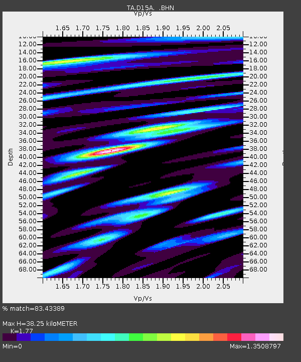
| Estimated Moho Depth: |
38.25 km |
| Estimated Crust Vp/Vs: |
1.77 |
| Assumed Crust Vp: |
6.353 km/s |
| Estimated Crust Vs: |
3.589 km/s |
| Estimated Crust Poisson's Ratio: |
0.27 |
|
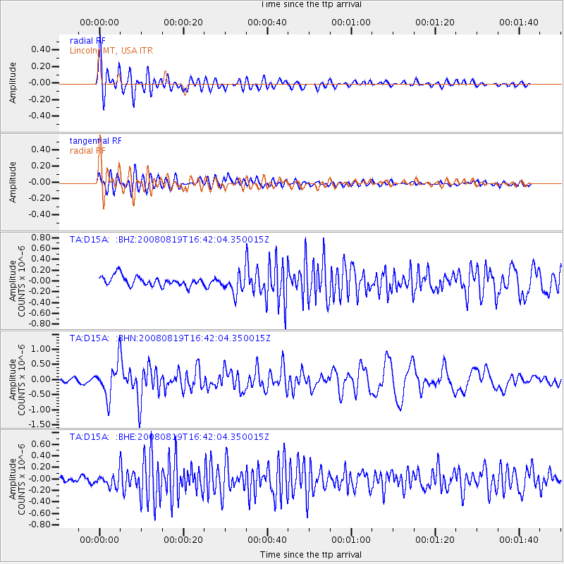
| Radial Match: |
83.43389 % |
| Radial Bump: |
400 |
| Transverse Match: |
71.4656 % |
| Transverse Bump: |
400 |
| SOD ConfigId: |
2504 |
| Insert Time: |
2010-03-06 05:01:48.566 +0000 |
| GWidth: |
2.5 |
| Max Bumps: |
400 |
| Tol: |
0.001 |
|
Signal To Noise
| Channel | StoN | STA | LTA |
| TA:D15A: :BHN:20080819T16:42:04.350015Z | 7.51282 | 5.701408E-7 | 7.5889055E-8 |
| TA:D15A: :BHE:20080819T16:42:04.350015Z | 1.5729946 | 1.0796964E-7 | 6.8639544E-8 |
| TA:D15A: :BHZ:20080819T16:42:04.350015Z | 2.1063945 | 1.8609958E-7 | 8.834982E-8 |
| Arrivals |
| Ps | 4.8 SECOND |
| PpPs | 16 SECOND |
| PsPs/PpSs | 21 SECOND |


