You are here: Home > Network List > TA - USArray Transportable Network (new EarthScope stations) Stations List
> Station I29M Ogilvie Camp, Yukon, CA > Earthquake Result Viewer
I29M Ogilvie Camp, Yukon, CA - Earthquake Result Viewer
| Earthquake location: |
Off East Coast Of Honshu, Japan |
| Earthquake latitude/longitude: |
37.5/144.0 |
| Earthquake time(UTC): |
2017/10/06 (279) 07:59:33 GMT |
| Earthquake Depth: |
10 km |
| Earthquake Magnitude: |
6.0 Mww |
| Earthquake Catalog/Contributor: |
NEIC PDE/us |
|
| Network: |
TA USArray Transportable Network (new EarthScope stations) |
| Station: |
I29M Ogilvie Camp, Yukon, CA |
| Lat/Lon: |
65.36 N/138.31 W |
| Elevation: |
602 m |
|
| Distance: |
51.6 deg |
| Az: |
31.509 deg |
| Baz: |
277.38 deg |
| Ray Param: |
0.0673004 |
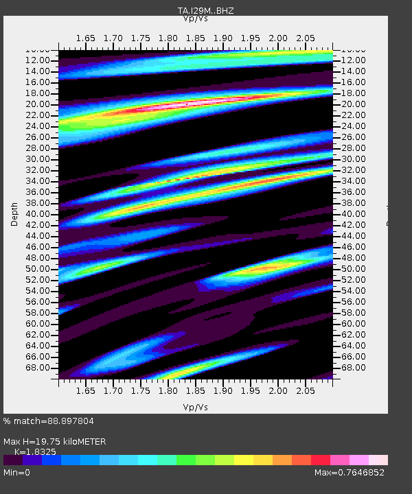
| Estimated Moho Depth: |
19.75 km |
| Estimated Crust Vp/Vs: |
1.83 |
| Assumed Crust Vp: |
6.566 km/s |
| Estimated Crust Vs: |
3.583 km/s |
| Estimated Crust Poisson's Ratio: |
0.29 |
|
| Radial Match: |
88.897804 % |
| Radial Bump: |
400 |
| Transverse Match: |
72.9036 % |
| Transverse Bump: |
400 |
| SOD ConfigId: |
13570011 |
| Insert Time: |
2019-04-28 22:43:04.512 +0000 |
| GWidth: |
2.5 |
| Max Bumps: |
400 |
| Tol: |
0.001 |
|

Signal To Noise
| Channel | StoN | STA | LTA |
| TA:I29M: :BHZ:20171006T08:08:08.22499Z | 11.229436 | 2.849115E-6 | 2.5371844E-7 |
| TA:I29M: :BHN:20171006T08:08:08.22499Z | 3.0015888 | 5.9171754E-7 | 1.9713478E-7 |
| TA:I29M: :BHE:20171006T08:08:08.22499Z | 11.705894 | 1.4887438E-6 | 1.2717899E-7 |
| Arrivals |
| Ps | 2.7 SECOND |
| PpPs | 8.0 SECOND |
| PsPs/PpSs | 11 SECOND |


