You are here: Home > Network List > TA - USArray Transportable Network (new EarthScope stations) Stations List
> Station D15A Lincoln, MT, USA > Earthquake Result Viewer
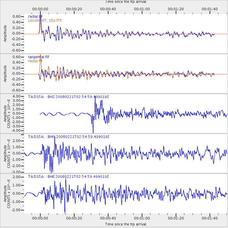
D15A Lincoln, MT, USA - Earthquake Result Viewer

| Earthquake location: |
Svalbard Region |
| Earthquake latitude/longitude: |
77.1/18.6 |
| Earthquake time(UTC): |
2008/02/21 (052) 02:46:17 GMT |
| Earthquake Depth: |
10 km |
| Earthquake Magnitude: |
5.7 MB, 5.9 MS, 6.1 MW, 6.0 MW |
| Earthquake Catalog/Contributor: |
WHDF/NEIC |
|
| Network: |
TA USArray Transportable Network (new EarthScope stations) |
| Station: |
D15A Lincoln, MT, USA |
| Lat/Lon: |
47.04 N/112.52 W |
| Elevation: |
1593 m |
|
| Distance: |
52.4 deg |
| Az: |
319.438 deg |
| Baz: |
12.354 deg |
| Ray Param: |
0.06676317 |
| Estimated Moho Depth: |
46.25 km |
| Estimated Crust Vp/Vs: |
1.64 |
| Assumed Crust Vp: |
6.353 km/s |
| Estimated Crust Vs: |
3.874 km/s |
| Estimated Crust Poisson's Ratio: |
0.20 |
|
| Radial Match: |
85.61061 % |
| Radial Bump: |
400 |
| Transverse Match: |
71.312325 % |
| Transverse Bump: |
400 |
| SOD ConfigId: |
2564 |
| Insert Time: |
2010-03-06 05:02:09.259 +0000 |
| GWidth: |
2.5 |
| Max Bumps: |
400 |
| Tol: |
0.001 |
|
Signal To Noise
| Channel | StoN | STA | LTA |
| TA:D15A: :BHN:20080221T02:54:59.499019Z | 3.4545608 | 8.2475606E-7 | 2.3874412E-7 |
| TA:D15A: :BHE:20080221T02:54:59.499019Z | 2.603987 | 4.6515353E-7 | 1.786313E-7 |
| TA:D15A: :BHZ:20080221T02:54:59.499019Z | 7.193216 | 1.6239569E-6 | 2.2576229E-7 |
| Arrivals |
| Ps | 4.9 SECOND |
| PpPs | 18 SECOND |
| PsPs/PpSs | 23 SECOND |


