You are here: Home > Network List > TA - USArray Transportable Network (new EarthScope stations) Stations List
> Station MSTX Muleshoe, TX, USA > Earthquake Result Viewer
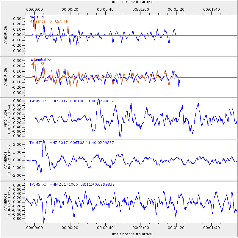
MSTX Muleshoe, TX, USA - Earthquake Result Viewer
*The percent match for this event was below the threshold and hence no stack was calculated.
| Earthquake location: |
Off East Coast Of Honshu, Japan |
| Earthquake latitude/longitude: |
37.5/144.0 |
| Earthquake time(UTC): |
2017/10/06 (279) 07:59:33 GMT |
| Earthquake Depth: |
10 km |
| Earthquake Magnitude: |
6.0 Mww |
| Earthquake Catalog/Contributor: |
NEIC PDE/us |
|
| Network: |
TA USArray Transportable Network (new EarthScope stations) |
| Station: |
MSTX Muleshoe, TX, USA |
| Lat/Lon: |
33.97 N/102.77 W |
| Elevation: |
1167 m |
|
| Distance: |
85.7 deg |
| Az: |
49.964 deg |
| Baz: |
312.873 deg |
| Ray Param: |
$rayparam |
*The percent match for this event was below the threshold and hence was not used in the summary stack. |
|
| Radial Match: |
69.97671 % |
| Radial Bump: |
324 |
| Transverse Match: |
71.52536 % |
| Transverse Bump: |
400 |
| SOD ConfigId: |
13570011 |
| Insert Time: |
2019-04-28 22:43:41.790 +0000 |
| GWidth: |
2.5 |
| Max Bumps: |
400 |
| Tol: |
0.001 |
|
Signal To Noise
| Channel | StoN | STA | LTA |
| TA:MSTX: :HHZ:20171006T08:11:40.029983Z | 8.2964735 | 9.840253E-7 | 1.1860766E-7 |
| TA:MSTX: :HHN:20171006T08:11:40.029983Z | 1.5972039 | 2.3771099E-7 | 1.4882947E-7 |
| TA:MSTX: :HHE:20171006T08:11:40.029983Z | 2.8874333 | 3.1723363E-7 | 1.09866996E-7 |
| Arrivals |
| Ps | |
| PpPs | |
| PsPs/PpSs | |


