You are here: Home > Network List > TA - USArray Transportable Network (new EarthScope stations) Stations List
> Station D15A Lincoln, MT, USA > Earthquake Result Viewer
D15A Lincoln, MT, USA - Earthquake Result Viewer
| Earthquake location: |
Hokkaido, Japan Region |
| Earthquake latitude/longitude: |
41.8/143.4 |
| Earthquake time(UTC): |
2009/06/05 (156) 03:30:33 GMT |
| Earthquake Depth: |
29 km |
| Earthquake Magnitude: |
6.0 MB, 6.3 MS, 6.4 MW, 6.4 MW |
| Earthquake Catalog/Contributor: |
WHDF/NEIC |
|
| Network: |
TA USArray Transportable Network (new EarthScope stations) |
| Station: |
D15A Lincoln, MT, USA |
| Lat/Lon: |
47.04 N/112.52 W |
| Elevation: |
1593 m |
|
| Distance: |
68.9 deg |
| Az: |
45.349 deg |
| Baz: |
308.972 deg |
| Ray Param: |
0.055989735 |
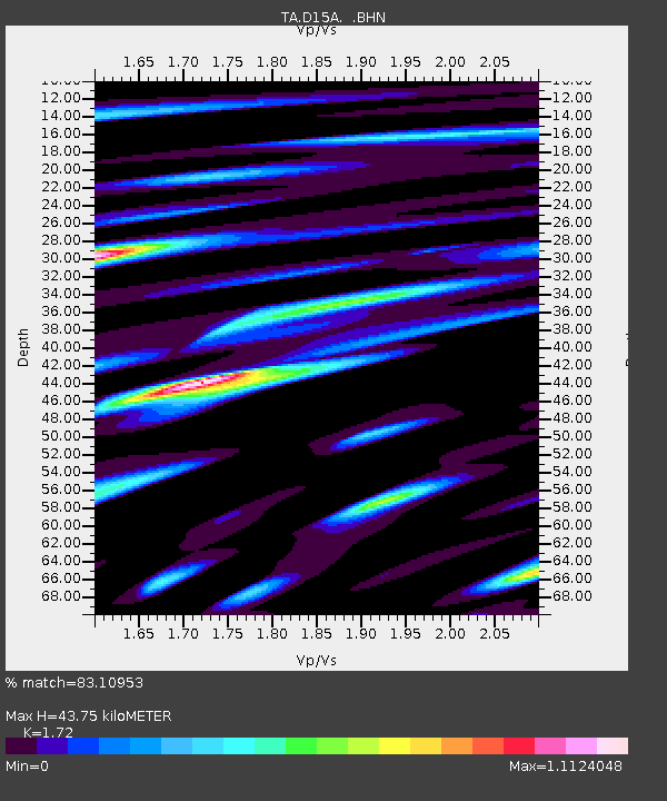
| Estimated Moho Depth: |
43.75 km |
| Estimated Crust Vp/Vs: |
1.72 |
| Assumed Crust Vp: |
6.353 km/s |
| Estimated Crust Vs: |
3.694 km/s |
| Estimated Crust Poisson's Ratio: |
0.24 |
|
| Radial Match: |
83.10953 % |
| Radial Bump: |
400 |
| Transverse Match: |
31.088469 % |
| Transverse Bump: |
400 |
| SOD ConfigId: |
2648 |
| Insert Time: |
2010-03-06 05:02:16.044 +0000 |
| GWidth: |
2.5 |
| Max Bumps: |
400 |
| Tol: |
0.001 |
|
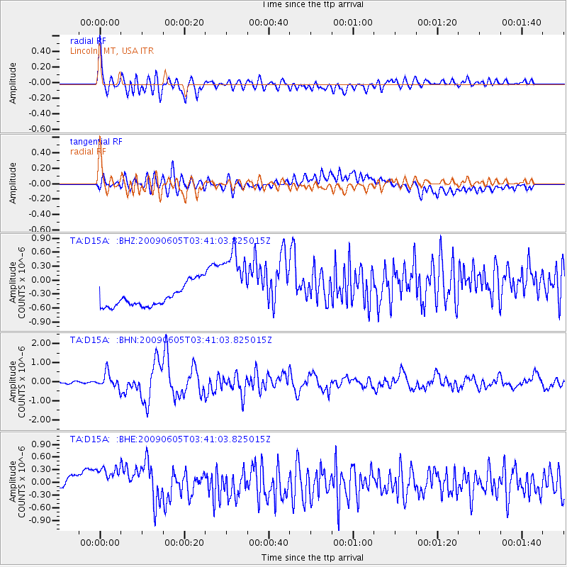
Signal To Noise
| Channel | StoN | STA | LTA |
| TA:D15A: :BHN:20090605T03:41:03.825015Z | 10.633195 | 4.00825E-7 | 3.769563E-8 |
| TA:D15A: :BHE:20090605T03:41:03.825015Z | 2.2962193 | 5.153428E-7 | 2.24431E-7 |
| TA:D15A: :BHZ:20090605T03:41:03.825015Z | 3.321296 | 7.876946E-7 | 2.3716484E-7 |
| Arrivals |
| Ps | 5.2 SECOND |
| PpPs | 18 SECOND |
| PsPs/PpSs | 23 SECOND |


