You are here: Home > Network List > TA - USArray Transportable Network (new EarthScope stations) Stations List
> Station O17K Koliganek, Bristol Bay, AK, USA > Earthquake Result Viewer
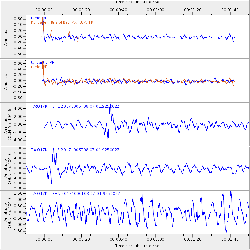
O17K Koliganek, Bristol Bay, AK, USA - Earthquake Result Viewer
*The percent match for this event was below the threshold and hence no stack was calculated.
| Earthquake location: |
Off East Coast Of Honshu, Japan |
| Earthquake latitude/longitude: |
37.5/144.0 |
| Earthquake time(UTC): |
2017/10/06 (279) 07:59:33 GMT |
| Earthquake Depth: |
10 km |
| Earthquake Magnitude: |
6.0 Mww |
| Earthquake Catalog/Contributor: |
NEIC PDE/us |
|
| Network: |
TA USArray Transportable Network (new EarthScope stations) |
| Station: |
O17K Koliganek, Bristol Bay, AK, USA |
| Lat/Lon: |
59.77 N/157.09 W |
| Elevation: |
156 m |
|
| Distance: |
43.1 deg |
| Az: |
39.383 deg |
| Baz: |
266.03 deg |
| Ray Param: |
$rayparam |
*The percent match for this event was below the threshold and hence was not used in the summary stack. |
|
| Radial Match: |
61.12312 % |
| Radial Bump: |
368 |
| Transverse Match: |
50.043556 % |
| Transverse Bump: |
400 |
| SOD ConfigId: |
13570011 |
| Insert Time: |
2019-04-28 22:43:51.858 +0000 |
| GWidth: |
2.5 |
| Max Bumps: |
400 |
| Tol: |
0.001 |
|
Signal To Noise
| Channel | StoN | STA | LTA |
| TA:O17K: :BHZ:20171006T08:07:01.925002Z | 3.4641898 | 2.5563465E-6 | 7.3793495E-7 |
| TA:O17K: :BHN:20171006T08:07:01.925002Z | 0.89728814 | 4.4080318E-7 | 4.912616E-7 |
| TA:O17K: :BHE:20171006T08:07:01.925002Z | 2.580101 | 1.596457E-6 | 6.1875755E-7 |
| Arrivals |
| Ps | |
| PpPs | |
| PsPs/PpSs | |


