You are here: Home > Network List > TA - USArray Transportable Network (new EarthScope stations) Stations List
> Station S22A 4UR Ranch, Creede, CO, USA > Earthquake Result Viewer
S22A 4UR Ranch, Creede, CO, USA - Earthquake Result Viewer

| Earthquake location: |
Off East Coast Of Honshu, Japan |
| Earthquake latitude/longitude: |
37.5/144.0 |
| Earthquake time(UTC): |
2017/10/06 (279) 07:59:33 GMT |
| Earthquake Depth: |
10 km |
| Earthquake Magnitude: |
6.0 Mww |
| Earthquake Catalog/Contributor: |
NEIC PDE/us |
|
| Network: |
TA USArray Transportable Network (new EarthScope stations) |
| Station: |
S22A 4UR Ranch, Creede, CO, USA |
| Lat/Lon: |
37.75 N/106.83 W |
| Elevation: |
2626 m |
|
| Distance: |
80.7 deg |
| Az: |
49.336 deg |
| Baz: |
310.431 deg |
| Ray Param: |
0.04810797 |
| Estimated Moho Depth: |
42.5 km |
| Estimated Crust Vp/Vs: |
1.98 |
| Assumed Crust Vp: |
6.159 km/s |
| Estimated Crust Vs: |
3.107 km/s |
| Estimated Crust Poisson's Ratio: |
0.33 |
|
| Radial Match: |
91.445564 % |
| Radial Bump: |
400 |
| Transverse Match: |
79.999596 % |
| Transverse Bump: |
400 |
| SOD ConfigId: |
13570011 |
| Insert Time: |
2019-04-28 22:44:15.943 +0000 |
| GWidth: |
2.5 |
| Max Bumps: |
400 |
| Tol: |
0.001 |
|
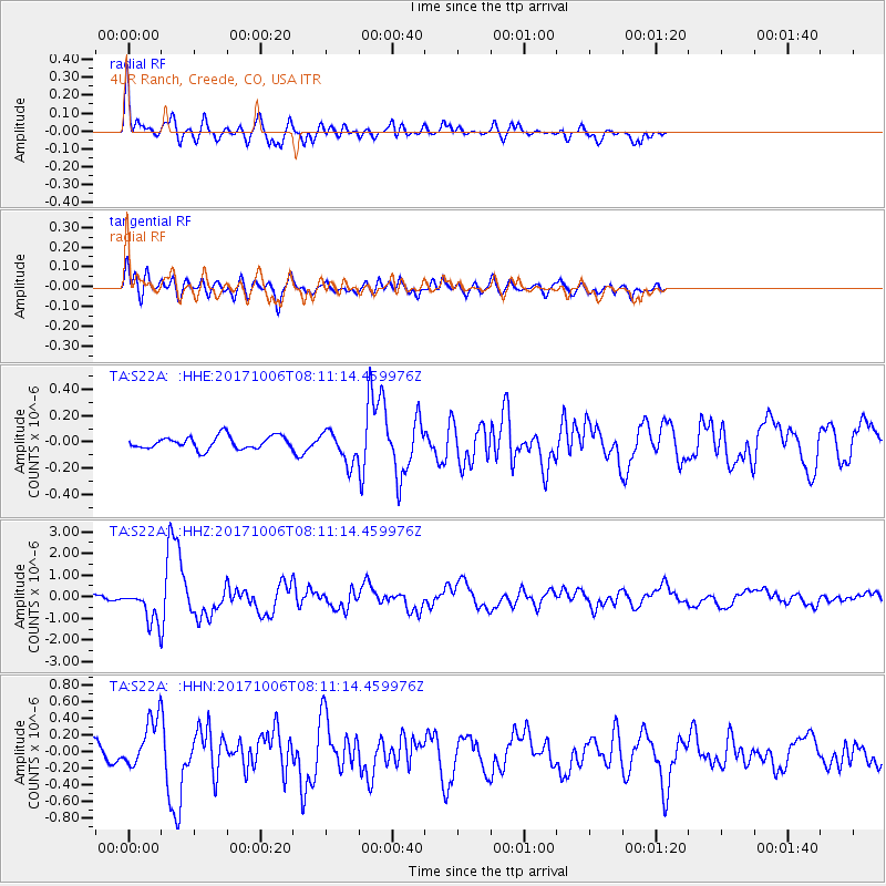
Signal To Noise
| Channel | StoN | STA | LTA |
| TA:S22A: :HHZ:20171006T08:11:14.459976Z | 4.804921 | 8.3538737E-7 | 1.7386078E-7 |
| TA:S22A: :HHN:20171006T08:11:14.459976Z | 2.4397116 | 3.0541216E-7 | 1.2518372E-7 |
| TA:S22A: :HHE:20171006T08:11:14.459976Z | 2.865093 | 1.3994594E-7 | 4.8845166E-8 |
| Arrivals |
| Ps | 6.9 SECOND |
| PpPs | 20 SECOND |
| PsPs/PpSs | 27 SECOND |


