You are here: Home > Network List > TA - USArray Transportable Network (new EarthScope stations) Stations List
> Station SFIN Lafayette, IN, USA > Earthquake Result Viewer
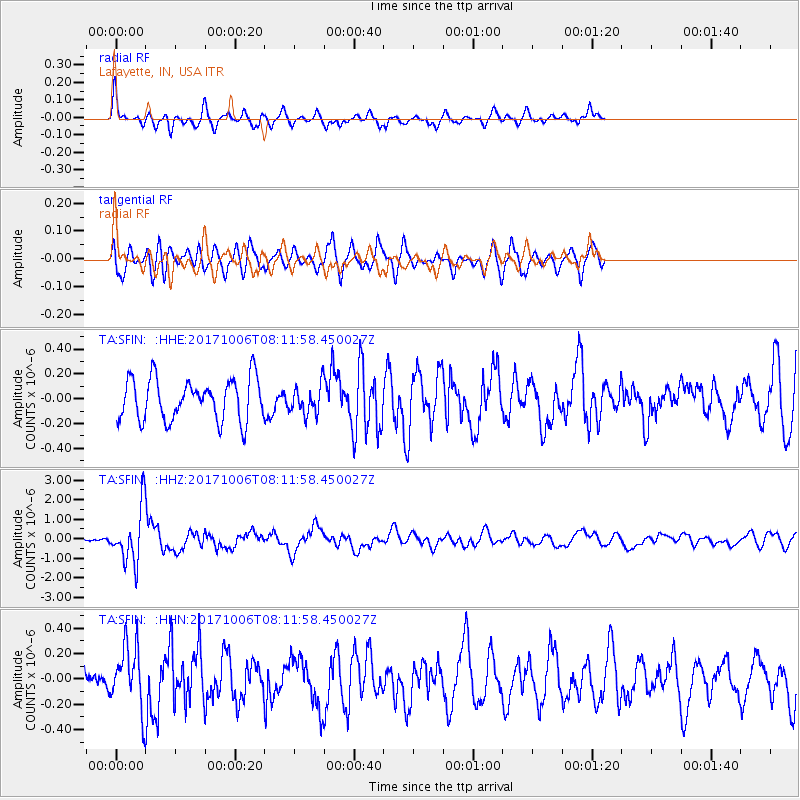
SFIN Lafayette, IN, USA - Earthquake Result Viewer
*The percent match for this event was below the threshold and hence no stack was calculated.
| Earthquake location: |
Off East Coast Of Honshu, Japan |
| Earthquake latitude/longitude: |
37.5/144.0 |
| Earthquake time(UTC): |
2017/10/06 (279) 07:59:33 GMT |
| Earthquake Depth: |
10 km |
| Earthquake Magnitude: |
6.0 Mww |
| Earthquake Catalog/Contributor: |
NEIC PDE/us |
|
| Network: |
TA USArray Transportable Network (new EarthScope stations) |
| Station: |
SFIN Lafayette, IN, USA |
| Lat/Lon: |
40.38 N/87.10 W |
| Elevation: |
165 m |
|
| Distance: |
89.5 deg |
| Az: |
36.45 deg |
| Baz: |
321.781 deg |
| Ray Param: |
$rayparam |
*The percent match for this event was below the threshold and hence was not used in the summary stack. |
|
| Radial Match: |
45.52267 % |
| Radial Bump: |
298 |
| Transverse Match: |
57.740913 % |
| Transverse Bump: |
400 |
| SOD ConfigId: |
13570011 |
| Insert Time: |
2019-04-28 22:44:17.341 +0000 |
| GWidth: |
2.5 |
| Max Bumps: |
400 |
| Tol: |
0.001 |
|
Signal To Noise
| Channel | StoN | STA | LTA |
| TA:SFIN: :HHZ:20171006T08:11:58.450027Z | 6.4258432 | 1.4006118E-6 | 2.1796545E-7 |
| TA:SFIN: :HHN:20171006T08:11:58.450027Z | 1.6442999 | 2.4766013E-7 | 1.5061737E-7 |
| TA:SFIN: :HHE:20171006T08:11:58.450027Z | 0.7266059 | 1.2122894E-7 | 1.6684278E-7 |
| Arrivals |
| Ps | |
| PpPs | |
| PsPs/PpSs | |


