You are here: Home > Network List > TA - USArray Transportable Network (new EarthScope stations) Stations List
> Station D15A Lincoln, MT, USA > Earthquake Result Viewer
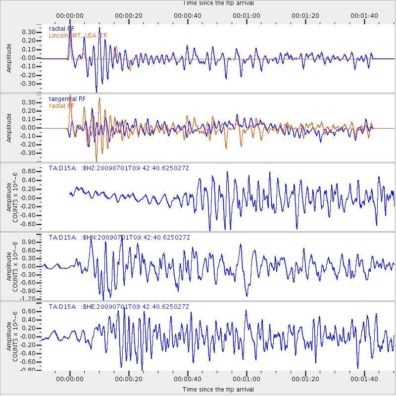
D15A Lincoln, MT, USA - Earthquake Result Viewer

| Earthquake location: |
Crete, Greece |
| Earthquake latitude/longitude: |
34.2/25.5 |
| Earthquake time(UTC): |
2009/07/01 (182) 09:30:10 GMT |
| Earthquake Depth: |
19 km |
| Earthquake Magnitude: |
6.1 MB, 6.3 MS, 6.4 MW, 6.4 MW |
| Earthquake Catalog/Contributor: |
WHDF/NEIC |
|
| Network: |
TA USArray Transportable Network (new EarthScope stations) |
| Station: |
D15A Lincoln, MT, USA |
| Lat/Lon: |
47.04 N/112.52 W |
| Elevation: |
1593 m |
|
| Distance: |
90.8 deg |
| Az: |
332.758 deg |
| Baz: |
33.709 deg |
| Ray Param: |
0.041647762 |
| Estimated Moho Depth: |
23.0 km |
| Estimated Crust Vp/Vs: |
1.81 |
| Assumed Crust Vp: |
6.353 km/s |
| Estimated Crust Vs: |
3.52 km/s |
| Estimated Crust Poisson's Ratio: |
0.28 |
|
| Radial Match: |
82.75732 % |
| Radial Bump: |
400 |
| Transverse Match: |
58.848866 % |
| Transverse Bump: |
400 |
| SOD ConfigId: |
2648 |
| Insert Time: |
2010-03-06 05:02:34.887 +0000 |
| GWidth: |
2.5 |
| Max Bumps: |
400 |
| Tol: |
0.001 |
|
Signal To Noise
| Channel | StoN | STA | LTA |
| TA:D15A: :BHN:20090701T09:42:40.625027Z | 2.5037649 | 1.3544648E-7 | 5.4097132E-8 |
| TA:D15A: :BHE:20090701T09:42:40.625027Z | 1.718477 | 1.7880211E-7 | 1.0404685E-7 |
| TA:D15A: :BHZ:20090701T09:42:40.625027Z | 2.0032437 | 1.5715304E-7 | 7.844928E-8 |
| Arrivals |
| Ps | 3.0 SECOND |
| PpPs | 10.0 SECOND |
| PsPs/PpSs | 13 SECOND |


