You are here: Home > Network List > TM - Thai Seismic Monitoring Network Stations List
> Station LOEI LOEI staion > Earthquake Result Viewer
LOEI LOEI staion - Earthquake Result Viewer
| Earthquake location: |
Off East Coast Of Honshu, Japan |
| Earthquake latitude/longitude: |
37.5/144.0 |
| Earthquake time(UTC): |
2017/10/06 (279) 07:59:33 GMT |
| Earthquake Depth: |
10 km |
| Earthquake Magnitude: |
6.0 Mww |
| Earthquake Catalog/Contributor: |
NEIC PDE/us |
|
| Network: |
TM Thai Seismic Monitoring Network |
| Station: |
LOEI LOEI staion |
| Lat/Lon: |
17.51 N/101.62 E |
| Elevation: |
305 m |
|
| Distance: |
42.1 deg |
| Az: |
253.559 deg |
| Baz: |
53.086 deg |
| Ray Param: |
0.07339265 |
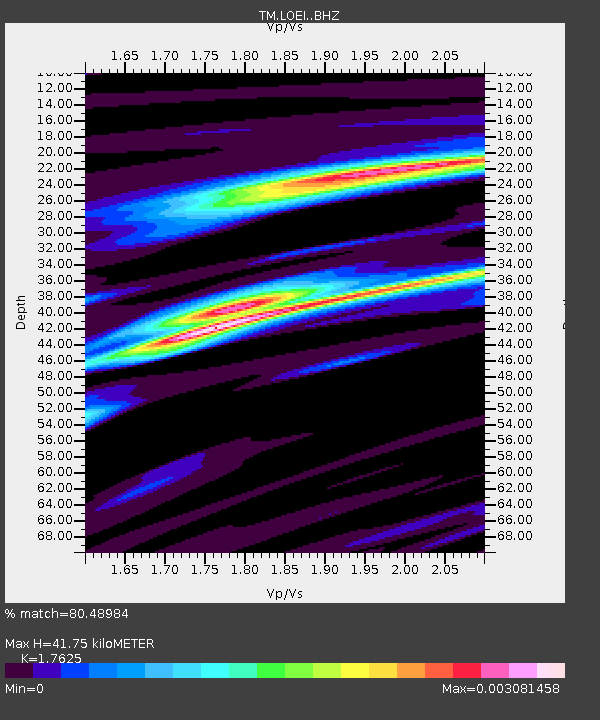
| Estimated Moho Depth: |
41.75 km |
| Estimated Crust Vp/Vs: |
1.76 |
| Assumed Crust Vp: |
6.35 km/s |
| Estimated Crust Vs: |
3.603 km/s |
| Estimated Crust Poisson's Ratio: |
0.26 |
|
| Radial Match: |
80.48984 % |
| Radial Bump: |
264 |
| Transverse Match: |
80.67904 % |
| Transverse Bump: |
246 |
| SOD ConfigId: |
13570011 |
| Insert Time: |
2019-04-28 22:44:33.124 +0000 |
| GWidth: |
2.5 |
| Max Bumps: |
400 |
| Tol: |
0.001 |
|

Signal To Noise
| Channel | StoN | STA | LTA |
| TM:LOEI: :BHZ:20171006T08:06:54.439987Z | 0.611109 | 2.9113278E-4 | 4.7640072E-4 |
| TM:LOEI: :BHN:20171006T08:06:54.439987Z | 1.0484915 | 5.523903E-6 | 5.2684286E-6 |
| TM:LOEI: :BHE:20171006T08:06:54.439987Z | 4.503631 | 3.1608948E-7 | 7.018547E-8 |
| Arrivals |
| Ps | 5.4 SECOND |
| PpPs | 17 SECOND |
| PsPs/PpSs | 22 SECOND |


