You are here: Home > Network List > TA - USArray Transportable Network (new EarthScope stations) Stations List
> Station D15A Lincoln, MT, USA > Earthquake Result Viewer
D15A Lincoln, MT, USA - Earthquake Result Viewer

| Earthquake location: |
Southern Peru |
| Earthquake latitude/longitude: |
-15.0/-70.4 |
| Earthquake time(UTC): |
2009/07/12 (193) 06:12:47 GMT |
| Earthquake Depth: |
199 km |
| Earthquake Magnitude: |
5.7 MB, 6.1 MW, 6.1 MW |
| Earthquake Catalog/Contributor: |
WHDF/NEIC |
|
| Network: |
TA USArray Transportable Network (new EarthScope stations) |
| Station: |
D15A Lincoln, MT, USA |
| Lat/Lon: |
47.04 N/112.52 W |
| Elevation: |
1593 m |
|
| Distance: |
72.4 deg |
| Az: |
331.263 deg |
| Baz: |
137.217 deg |
| Ray Param: |
0.053150717 |
| Estimated Moho Depth: |
23.0 km |
| Estimated Crust Vp/Vs: |
1.68 |
| Assumed Crust Vp: |
6.353 km/s |
| Estimated Crust Vs: |
3.787 km/s |
| Estimated Crust Poisson's Ratio: |
0.22 |
|
| Radial Match: |
91.31 % |
| Radial Bump: |
400 |
| Transverse Match: |
84.73775 % |
| Transverse Bump: |
400 |
| SOD ConfigId: |
2648 |
| Insert Time: |
2010-03-06 05:02:45.466 +0000 |
| GWidth: |
2.5 |
| Max Bumps: |
400 |
| Tol: |
0.001 |
|
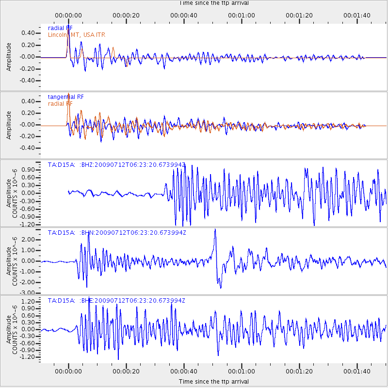
Signal To Noise
| Channel | StoN | STA | LTA |
| TA:D15A: :BHN:20090712T06:23:20.673994Z | 15.768263 | 6.4450444E-7 | 4.087352E-8 |
| TA:D15A: :BHE:20090712T06:23:20.673994Z | 5.6069098 | 2.5756236E-7 | 4.59366E-8 |
| TA:D15A: :BHZ:20090712T06:23:20.673994Z | 2.2886648 | 1.4342933E-7 | 6.2669436E-8 |
| Arrivals |
| Ps | 2.5 SECOND |
| PpPs | 9.4 SECOND |
| PsPs/PpSs | 12 SECOND |


