You are here: Home > Network List > TA - USArray Transportable Network (new EarthScope stations) Stations List
> Station D15A Lincoln, MT, USA > Earthquake Result Viewer
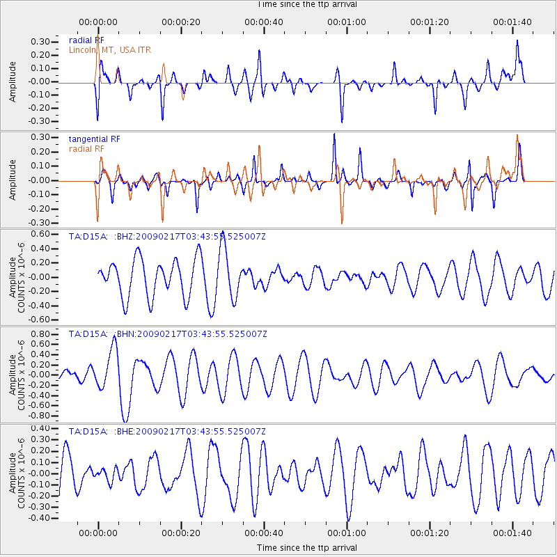
D15A Lincoln, MT, USA - Earthquake Result Viewer
*The percent match for this event was below the threshold and hence no stack was calculated.
| Earthquake location: |
Kermadec Islands, New Zealand |
| Earthquake latitude/longitude: |
-30.7/-178.6 |
| Earthquake time(UTC): |
2009/02/17 (048) 03:30:53 GMT |
| Earthquake Depth: |
13 km |
| Earthquake Magnitude: |
5.5 MS, 5.4 MB, 6.0 MW, 6.0 MW |
| Earthquake Catalog/Contributor: |
WHDF/NEIC |
|
| Network: |
TA USArray Transportable Network (new EarthScope stations) |
| Station: |
D15A Lincoln, MT, USA |
| Lat/Lon: |
47.04 N/112.52 W |
| Elevation: |
1593 m |
|
| Distance: |
97.6 deg |
| Az: |
39.109 deg |
| Baz: |
232.585 deg |
| Ray Param: |
$rayparam |
*The percent match for this event was below the threshold and hence was not used in the summary stack. |
|
| Radial Match: |
62.35161 % |
| Radial Bump: |
400 |
| Transverse Match: |
44.078125 % |
| Transverse Bump: |
290 |
| SOD ConfigId: |
2658 |
| Insert Time: |
2010-03-06 05:03:17.239 +0000 |
| GWidth: |
2.5 |
| Max Bumps: |
400 |
| Tol: |
0.001 |
|
Signal To Noise
| Channel | StoN | STA | LTA |
| TA:D15A: :BHN:20090217T03:43:55.525007Z | 2.8738291 | 4.035259E-7 | 1.4041402E-7 |
| TA:D15A: :BHE:20090217T03:43:55.525007Z | 0.24280907 | 5.7864785E-8 | 2.3831394E-7 |
| TA:D15A: :BHZ:20090217T03:43:55.525007Z | 1.3743095 | 3.527582E-7 | 2.5668032E-7 |
| Arrivals |
| Ps | |
| PpPs | |
| PsPs/PpSs | |


