You are here: Home > Network List > TA - USArray Transportable Network (new EarthScope stations) Stations List
> Station D15A Lincoln, MT, USA > Earthquake Result Viewer
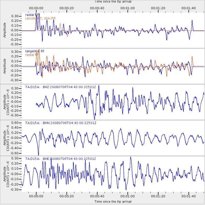
D15A Lincoln, MT, USA - Earthquake Result Viewer
*The percent match for this event was below the threshold and hence no stack was calculated.
| Earthquake location: |
South Of Fiji Islands |
| Earthquake latitude/longitude: |
-25.5/-176.4 |
| Earthquake time(UTC): |
2008/07/06 (188) 04:30:26 GMT |
| Earthquake Depth: |
49 km |
| Earthquake Magnitude: |
5.5 MB, 5.3 MS |
| Earthquake Catalog/Contributor: |
WHDF/NEIC |
|
| Network: |
TA USArray Transportable Network (new EarthScope stations) |
| Station: |
D15A Lincoln, MT, USA |
| Lat/Lon: |
47.04 N/112.52 W |
| Elevation: |
1593 m |
|
| Distance: |
92.2 deg |
| Az: |
37.9 deg |
| Baz: |
234.289 deg |
| Ray Param: |
$rayparam |
*The percent match for this event was below the threshold and hence was not used in the summary stack. |
|
| Radial Match: |
74.0761 % |
| Radial Bump: |
400 |
| Transverse Match: |
57.771763 % |
| Transverse Bump: |
400 |
| SOD ConfigId: |
2504 |
| Insert Time: |
2010-03-06 05:03:31.469 +0000 |
| GWidth: |
2.5 |
| Max Bumps: |
400 |
| Tol: |
0.001 |
|
Signal To Noise
| Channel | StoN | STA | LTA |
| TA:D15A: :BHN:20080706T04:43:00.32501Z | 3.1143413 | 2.6372166E-7 | 8.4679755E-8 |
| TA:D15A: :BHE:20080706T04:43:00.32501Z | 1.0877908 | 1.2220694E-7 | 1.1234415E-7 |
| TA:D15A: :BHZ:20080706T04:43:00.32501Z | 1.5396264 | 1.3960822E-7 | 9.0676686E-8 |
| Arrivals |
| Ps | |
| PpPs | |
| PsPs/PpSs | |


