You are here: Home > Network List > CI - Caltech Regional Seismic Network Stations List
> Station SMM Simmler, CA, USA > Earthquake Result Viewer
SMM Simmler, CA, USA - Earthquake Result Viewer
*The percent match for this event was below the threshold and hence no stack was calculated.
| Earthquake location: |
Northern Mid-Atlantic Ridge |
| Earthquake latitude/longitude: |
47.0/-27.3 |
| Earthquake time(UTC): |
2008/12/19 (354) 08:31:51 GMT |
| Earthquake Depth: |
2.0 km |
| Earthquake Magnitude: |
5.8 MB, 5.6 MS, 5.9 MW, 5.8 MW |
| Earthquake Catalog/Contributor: |
WHDF/NEIC |
|
| Network: |
CI Caltech Regional Seismic Network |
| Station: |
SMM Simmler, CA, USA |
| Lat/Lon: |
35.31 N/120.00 W |
| Elevation: |
599 m |
|
| Distance: |
66.9 deg |
| Az: |
297.322 deg |
| Baz: |
48.034 deg |
| Ray Param: |
$rayparam |
*The percent match for this event was below the threshold and hence was not used in the summary stack. |
|
| Radial Match: |
46.59442 % |
| Radial Bump: |
400 |
| Transverse Match: |
77.696175 % |
| Transverse Bump: |
400 |
| SOD ConfigId: |
2658 |
| Insert Time: |
2010-02-26 01:31:19.689 +0000 |
| GWidth: |
2.5 |
| Max Bumps: |
400 |
| Tol: |
0.001 |
|
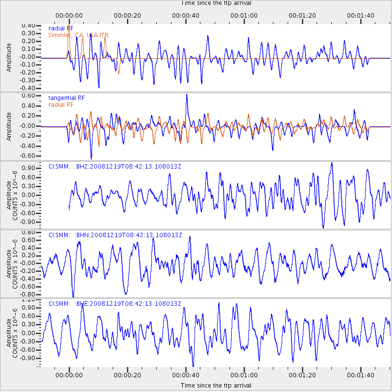
Signal To Noise
| Channel | StoN | STA | LTA |
| CI:SMM: :BHN:20081219T08:42:13.108013Z | 2.410653 | 4.225345E-7 | 1.7527802E-7 |
| CI:SMM: :BHE:20081219T08:42:13.108013Z | 1.4002607 | 5.8371376E-7 | 4.168608E-7 |
| CI:SMM: :BHZ:20081219T08:42:13.108013Z | 1.3991024 | 3.0694179E-7 | 2.1938477E-7 |
| Arrivals |
| Ps | |
| PpPs | |
| PsPs/PpSs | |


