You are here: Home > Network List > TA - USArray Transportable Network (new EarthScope stations) Stations List
> Station D15A Lincoln, MT, USA > Earthquake Result Viewer
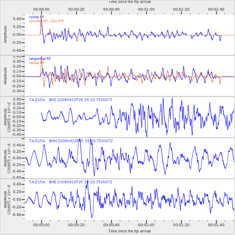
D15A Lincoln, MT, USA - Earthquake Result Viewer
*The percent match for this event was below the threshold and hence no stack was calculated.
| Earthquake location: |
Hokkaido, Japan Region |
| Earthquake latitude/longitude: |
41.5/142.0 |
| Earthquake time(UTC): |
2008/04/29 (120) 05:26:04 GMT |
| Earthquake Depth: |
47 km |
| Earthquake Magnitude: |
5.5 MB, 5.2 MS, 5.8 MW, 5.8 MW |
| Earthquake Catalog/Contributor: |
WHDF/NEIC |
|
| Network: |
TA USArray Transportable Network (new EarthScope stations) |
| Station: |
D15A Lincoln, MT, USA |
| Lat/Lon: |
47.04 N/112.52 W |
| Elevation: |
1593 m |
|
| Distance: |
69.9 deg |
| Az: |
44.596 deg |
| Baz: |
309.493 deg |
| Ray Param: |
$rayparam |
*The percent match for this event was below the threshold and hence was not used in the summary stack. |
|
| Radial Match: |
55.645996 % |
| Radial Bump: |
400 |
| Transverse Match: |
57.311214 % |
| Transverse Bump: |
400 |
| SOD ConfigId: |
2504 |
| Insert Time: |
2010-03-06 05:03:41.945 +0000 |
| GWidth: |
2.5 |
| Max Bumps: |
400 |
| Tol: |
0.001 |
|
Signal To Noise
| Channel | StoN | STA | LTA |
| TA:D15A: :BHN:20080429T05:36:39.750007Z | 2.122748 | 2.1636745E-7 | 1.01928E-7 |
| TA:D15A: :BHE:20080429T05:36:39.750007Z | 1.1124744 | 1.1212402E-7 | 1.0078796E-7 |
| TA:D15A: :BHZ:20080429T05:36:39.750007Z | 1.2462257 | 1.02530805E-7 | 8.2273054E-8 |
| Arrivals |
| Ps | |
| PpPs | |
| PsPs/PpSs | |


