You are here: Home > Network List > TA - USArray Transportable Network (new EarthScope stations) Stations List
> Station D15A Lincoln, MT, USA > Earthquake Result Viewer
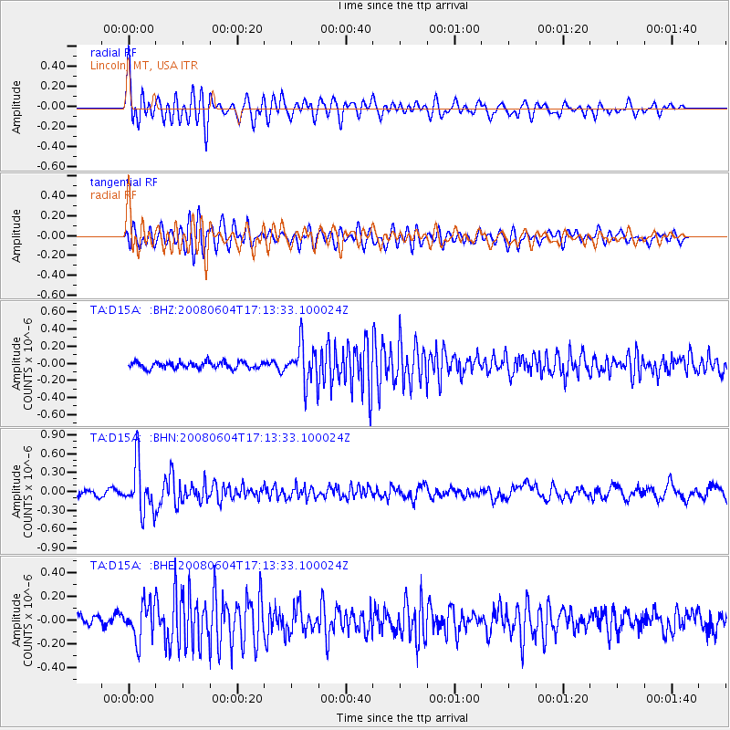
D15A Lincoln, MT, USA - Earthquake Result Viewer
*The percent match for this event was below the threshold and hence no stack was calculated.
| Earthquake location: |
Hokkaido, Japan Region |
| Earthquake latitude/longitude: |
41.5/139.0 |
| Earthquake time(UTC): |
2008/06/04 (156) 17:03:07 GMT |
| Earthquake Depth: |
213 km |
| Earthquake Magnitude: |
5.5 MB, 5.7 MW, 5.7 MW |
| Earthquake Catalog/Contributor: |
WHDF/NEIC |
|
| Network: |
TA USArray Transportable Network (new EarthScope stations) |
| Station: |
D15A Lincoln, MT, USA |
| Lat/Lon: |
47.04 N/112.52 W |
| Elevation: |
1593 m |
|
| Distance: |
71.4 deg |
| Az: |
43.215 deg |
| Baz: |
311.264 deg |
| Ray Param: |
$rayparam |
*The percent match for this event was below the threshold and hence was not used in the summary stack. |
|
| Radial Match: |
78.61625 % |
| Radial Bump: |
400 |
| Transverse Match: |
70.38222 % |
| Transverse Bump: |
400 |
| SOD ConfigId: |
2504 |
| Insert Time: |
2010-03-06 05:03:54.046 +0000 |
| GWidth: |
2.5 |
| Max Bumps: |
400 |
| Tol: |
0.001 |
|
Signal To Noise
| Channel | StoN | STA | LTA |
| TA:D15A: :BHN:20080604T17:13:33.100024Z | 6.8127723 | 3.9139525E-7 | 5.7450215E-8 |
| TA:D15A: :BHE:20080604T17:13:33.100024Z | 3.32413 | 1.5269599E-7 | 4.5935625E-8 |
| TA:D15A: :BHZ:20080604T17:13:33.100024Z | 6.0320435 | 2.3320494E-7 | 3.8661017E-8 |
| Arrivals |
| Ps | |
| PpPs | |
| PsPs/PpSs | |


