You are here: Home > Network List > KO - Kandilli Observatory Digital Broadband Seismic Network Stations List
> Station BALB Balikesir-Turkiye > Earthquake Result Viewer
BALB Balikesir-Turkiye - Earthquake Result Viewer
| Earthquake location: |
Near East Coast Of Honshu, Japan |
| Earthquake latitude/longitude: |
37.1/141.2 |
| Earthquake time(UTC): |
2017/10/06 (279) 14:56:40 GMT |
| Earthquake Depth: |
47 km |
| Earthquake Magnitude: |
5.4 Mww |
| Earthquake Catalog/Contributor: |
NEIC PDE/us |
|
| Network: |
KO Kandilli Observatory Digital Broadband Seismic Network |
| Station: |
BALB Balikesir-Turkiye |
| Lat/Lon: |
39.64 N/27.88 E |
| Elevation: |
120 m |
|
| Distance: |
82.1 deg |
| Az: |
314.284 deg |
| Baz: |
47.838 deg |
| Ray Param: |
0.04703493 |
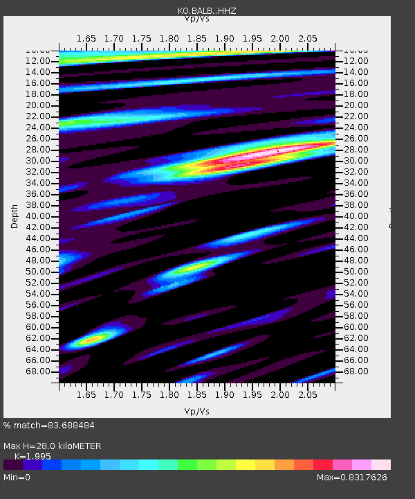
| Estimated Moho Depth: |
28.0 km |
| Estimated Crust Vp/Vs: |
2.00 |
| Assumed Crust Vp: |
6.155 km/s |
| Estimated Crust Vs: |
3.085 km/s |
| Estimated Crust Poisson's Ratio: |
0.33 |
|
| Radial Match: |
83.688484 % |
| Radial Bump: |
400 |
| Transverse Match: |
69.38423 % |
| Transverse Bump: |
400 |
| SOD ConfigId: |
13570011 |
| Insert Time: |
2019-04-28 22:50:25.097 +0000 |
| GWidth: |
2.5 |
| Max Bumps: |
400 |
| Tol: |
0.001 |
|

Signal To Noise
| Channel | StoN | STA | LTA |
| KO:BALB: :HHZ:20171006T15:08:25.030012Z | 10.412786 | 9.877187E-7 | 9.485635E-8 |
| KO:BALB: :HHN:20171006T15:08:25.030012Z | 2.164117 | 2.0467166E-7 | 9.4575135E-8 |
| KO:BALB: :HHE:20171006T15:08:25.030012Z | 3.156835 | 2.6872272E-7 | 8.512409E-8 |
| Arrivals |
| Ps | 4.6 SECOND |
| PpPs | 13 SECOND |
| PsPs/PpSs | 18 SECOND |


