You are here: Home > Network List > CI - Caltech Regional Seismic Network Stations List
> Station SMM Simmler, CA, USA > Earthquake Result Viewer
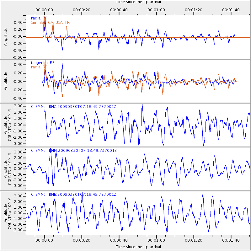
SMM Simmler, CA, USA - Earthquake Result Viewer
*The percent match for this event was below the threshold and hence no stack was calculated.
| Earthquake location: |
Kodiak Island Region, Alaska |
| Earthquake latitude/longitude: |
56.5/-152.7 |
| Earthquake time(UTC): |
2009/03/30 (089) 07:13:07 GMT |
| Earthquake Depth: |
21 km |
| Earthquake Magnitude: |
5.9 MB, 5.9 MS, 5.9 MW, 5.9 MW |
| Earthquake Catalog/Contributor: |
WHDF/NEIC |
|
| Network: |
CI Caltech Regional Seismic Network |
| Station: |
SMM Simmler, CA, USA |
| Lat/Lon: |
35.31 N/120.00 W |
| Elevation: |
599 m |
|
| Distance: |
30.7 deg |
| Az: |
119.861 deg |
| Baz: |
324.034 deg |
| Ray Param: |
$rayparam |
*The percent match for this event was below the threshold and hence was not used in the summary stack. |
|
| Radial Match: |
54.167168 % |
| Radial Bump: |
377 |
| Transverse Match: |
49.676266 % |
| Transverse Bump: |
400 |
| SOD ConfigId: |
2658 |
| Insert Time: |
2010-02-26 01:31:23.811 +0000 |
| GWidth: |
2.5 |
| Max Bumps: |
400 |
| Tol: |
0.001 |
|
Signal To Noise
| Channel | StoN | STA | LTA |
| CI:SMM: :BHN:20090330T07:18:49.737001Z | 2.096308 | 1.8564235E-6 | 8.855681E-7 |
| CI:SMM: :BHE:20090330T07:18:49.737001Z | 1.207226 | 1.1627694E-6 | 9.631747E-7 |
| CI:SMM: :BHZ:20090330T07:18:49.737001Z | 1.2022384 | 1.3506238E-6 | 1.1234243E-6 |
| Arrivals |
| Ps | |
| PpPs | |
| PsPs/PpSs | |


