You are here: Home > Network List > TA - USArray Transportable Network (new EarthScope stations) Stations List
> Station D15A Lincoln, MT, USA > Earthquake Result Viewer
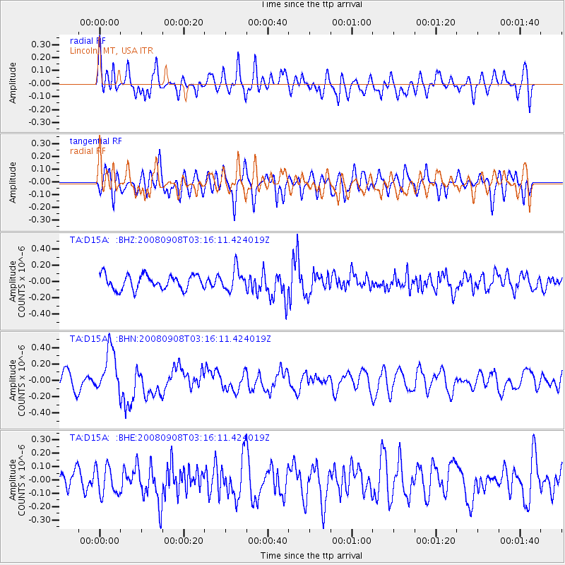
D15A Lincoln, MT, USA - Earthquake Result Viewer
*The percent match for this event was below the threshold and hence no stack was calculated.
| Earthquake location: |
Vanuatu Islands |
| Earthquake latitude/longitude: |
-20.0/169.1 |
| Earthquake time(UTC): |
2008/09/08 (252) 03:03:15 GMT |
| Earthquake Depth: |
36 km |
| Earthquake Magnitude: |
6.0 MB, 5.8 MS, 6.2 MW, 6.2 MW |
| Earthquake Catalog/Contributor: |
WHDF/NEIC |
|
| Network: |
TA USArray Transportable Network (new EarthScope stations) |
| Station: |
D15A Lincoln, MT, USA |
| Lat/Lon: |
47.04 N/112.52 W |
| Elevation: |
1593 m |
|
| Distance: |
96.8 deg |
| Az: |
42.422 deg |
| Baz: |
248.096 deg |
| Ray Param: |
$rayparam |
*The percent match for this event was below the threshold and hence was not used in the summary stack. |
|
| Radial Match: |
50.769466 % |
| Radial Bump: |
400 |
| Transverse Match: |
65.35991 % |
| Transverse Bump: |
400 |
| SOD ConfigId: |
2560 |
| Insert Time: |
2010-03-06 05:04:23.936 +0000 |
| GWidth: |
2.5 |
| Max Bumps: |
400 |
| Tol: |
0.001 |
|
Signal To Noise
| Channel | StoN | STA | LTA |
| TA:D15A: :BHN:20080908T03:16:11.424019Z | 2.8398917 | 2.805062E-7 | 9.877356E-8 |
| TA:D15A: :BHE:20080908T03:16:11.424019Z | 1.0728446 | 1.06153045E-7 | 9.894541E-8 |
| TA:D15A: :BHZ:20080908T03:16:11.424019Z | 1.5252379 | 1.3426246E-7 | 8.802723E-8 |
| Arrivals |
| Ps | |
| PpPs | |
| PsPs/PpSs | |


