You are here: Home > Network List > TA - USArray Transportable Network (new EarthScope stations) Stations List
> Station A19K Wainwright, AK, USA > Earthquake Result Viewer
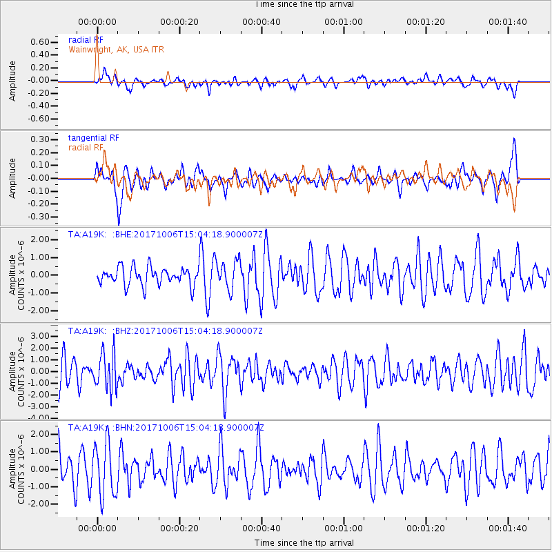
A19K Wainwright, AK, USA - Earthquake Result Viewer
*The percent match for this event was below the threshold and hence no stack was calculated.
| Earthquake location: |
Near East Coast Of Honshu, Japan |
| Earthquake latitude/longitude: |
37.1/141.2 |
| Earthquake time(UTC): |
2017/10/06 (279) 14:56:40 GMT |
| Earthquake Depth: |
47 km |
| Earthquake Magnitude: |
5.4 Mww |
| Earthquake Catalog/Contributor: |
NEIC PDE/us |
|
| Network: |
TA USArray Transportable Network (new EarthScope stations) |
| Station: |
A19K Wainwright, AK, USA |
| Lat/Lon: |
70.20 N/161.07 W |
| Elevation: |
24 m |
|
| Distance: |
44.8 deg |
| Az: |
24.151 deg |
| Baz: |
253.778 deg |
| Ray Param: |
$rayparam |
*The percent match for this event was below the threshold and hence was not used in the summary stack. |
|
| Radial Match: |
43.524563 % |
| Radial Bump: |
400 |
| Transverse Match: |
46.538044 % |
| Transverse Bump: |
400 |
| SOD ConfigId: |
13570011 |
| Insert Time: |
2019-04-28 22:53:37.519 +0000 |
| GWidth: |
2.5 |
| Max Bumps: |
400 |
| Tol: |
0.001 |
|
Signal To Noise
| Channel | StoN | STA | LTA |
| TA:A19K: :BHZ:20171006T15:04:18.900007Z | 1.4096047 | 1.5489452E-6 | 1.0988507E-6 |
| TA:A19K: :BHN:20171006T15:04:18.900007Z | 2.0159593 | 1.568658E-6 | 7.781199E-7 |
| TA:A19K: :BHE:20171006T15:04:18.900007Z | 1.5824261 | 7.9962075E-7 | 5.053132E-7 |
| Arrivals |
| Ps | |
| PpPs | |
| PsPs/PpSs | |


