You are here: Home > Network List > TA - USArray Transportable Network (new EarthScope stations) Stations List
> Station D23K Nanushuk River, AK USA > Earthquake Result Viewer
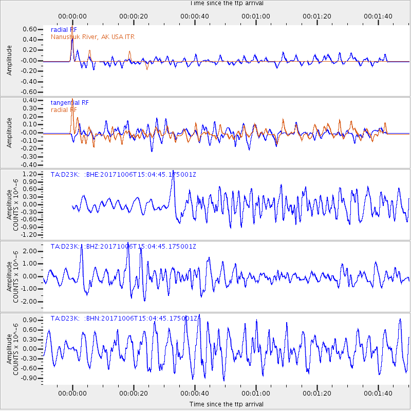
D23K Nanushuk River, AK USA - Earthquake Result Viewer
*The percent match for this event was below the threshold and hence no stack was calculated.
| Earthquake location: |
Near East Coast Of Honshu, Japan |
| Earthquake latitude/longitude: |
37.1/141.2 |
| Earthquake time(UTC): |
2017/10/06 (279) 14:56:40 GMT |
| Earthquake Depth: |
47 km |
| Earthquake Magnitude: |
5.4 Mww |
| Earthquake Catalog/Contributor: |
NEIC PDE/us |
|
| Network: |
TA USArray Transportable Network (new EarthScope stations) |
| Station: |
D23K Nanushuk River, AK USA |
| Lat/Lon: |
68.97 N/150.68 W |
| Elevation: |
406 m |
|
| Distance: |
48.1 deg |
| Az: |
26.746 deg |
| Baz: |
265.301 deg |
| Ray Param: |
$rayparam |
*The percent match for this event was below the threshold and hence was not used in the summary stack. |
|
| Radial Match: |
71.21006 % |
| Radial Bump: |
400 |
| Transverse Match: |
68.85051 % |
| Transverse Bump: |
400 |
| SOD ConfigId: |
13570011 |
| Insert Time: |
2019-04-28 22:53:50.131 +0000 |
| GWidth: |
2.5 |
| Max Bumps: |
400 |
| Tol: |
0.001 |
|
Signal To Noise
| Channel | StoN | STA | LTA |
| TA:D23K: :BHZ:20171006T15:04:45.175001Z | 2.6956577 | 9.929507E-7 | 3.6835195E-7 |
| TA:D23K: :BHN:20171006T15:04:45.175001Z | 0.7610854 | 2.5996212E-7 | 3.415676E-7 |
| TA:D23K: :BHE:20171006T15:04:45.175001Z | 3.0589776 | 5.5417354E-7 | 1.8116299E-7 |
| Arrivals |
| Ps | |
| PpPs | |
| PsPs/PpSs | |


