You are here: Home > Network List > TA - USArray Transportable Network (new EarthScope stations) Stations List
> Station D25K Kavik River, AK, USA > Earthquake Result Viewer
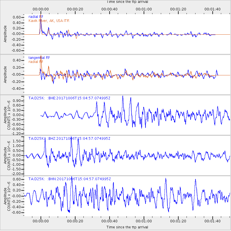
D25K Kavik River, AK, USA - Earthquake Result Viewer
*The percent match for this event was below the threshold and hence no stack was calculated.
| Earthquake location: |
Near East Coast Of Honshu, Japan |
| Earthquake latitude/longitude: |
37.1/141.2 |
| Earthquake time(UTC): |
2017/10/06 (279) 14:56:40 GMT |
| Earthquake Depth: |
47 km |
| Earthquake Magnitude: |
5.4 Mww |
| Earthquake Catalog/Contributor: |
NEIC PDE/us |
|
| Network: |
TA USArray Transportable Network (new EarthScope stations) |
| Station: |
D25K Kavik River, AK, USA |
| Lat/Lon: |
69.32 N/146.38 W |
| Elevation: |
770 m |
|
| Distance: |
49.7 deg |
| Az: |
26.372 deg |
| Baz: |
269.075 deg |
| Ray Param: |
$rayparam |
*The percent match for this event was below the threshold and hence was not used in the summary stack. |
|
| Radial Match: |
75.448044 % |
| Radial Bump: |
400 |
| Transverse Match: |
63.26294 % |
| Transverse Bump: |
400 |
| SOD ConfigId: |
13570011 |
| Insert Time: |
2019-04-28 22:53:52.323 +0000 |
| GWidth: |
2.5 |
| Max Bumps: |
400 |
| Tol: |
0.001 |
|
Signal To Noise
| Channel | StoN | STA | LTA |
| TA:D25K: :BHZ:20171006T15:04:57.074995Z | 4.6057296 | 7.160638E-7 | 1.5547239E-7 |
| TA:D25K: :BHN:20171006T15:04:57.074995Z | 1.029554 | 1.5704256E-7 | 1.5253455E-7 |
| TA:D25K: :BHE:20171006T15:04:57.074995Z | 3.227551 | 3.8502128E-7 | 1.1929208E-7 |
| Arrivals |
| Ps | |
| PpPs | |
| PsPs/PpSs | |


