You are here: Home > Network List > TA - USArray Transportable Network (new EarthScope stations) Stations List
> Station F26K Sheenjek River, AK, USA > Earthquake Result Viewer
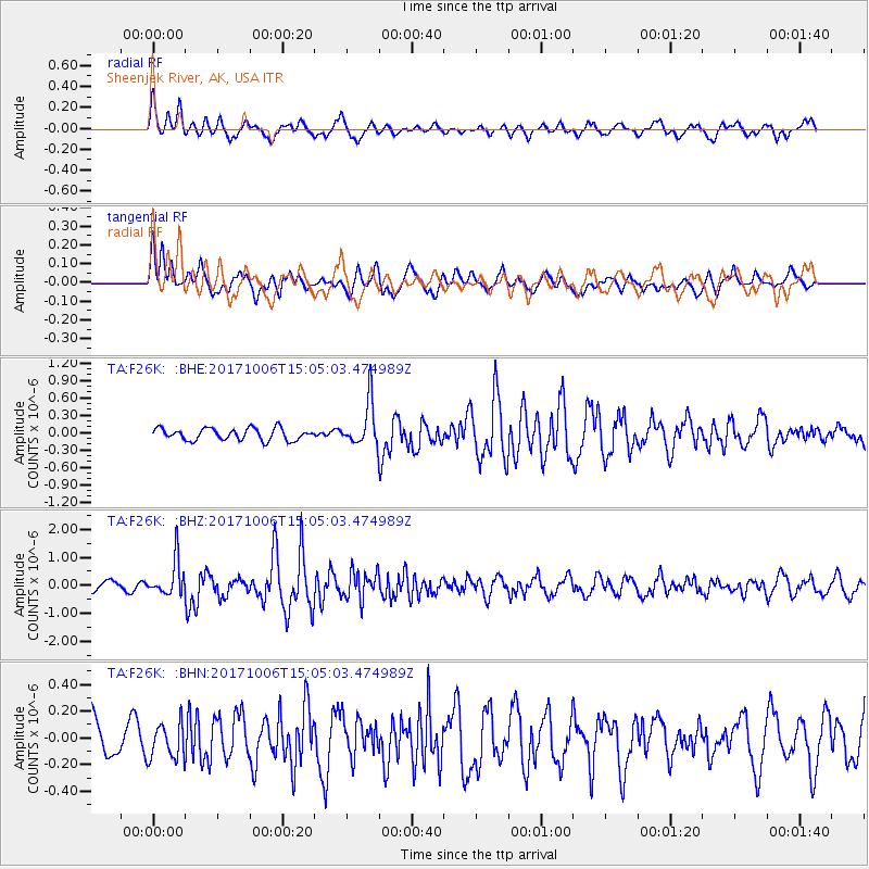
F26K Sheenjek River, AK, USA - Earthquake Result Viewer
*The percent match for this event was below the threshold and hence no stack was calculated.
| Earthquake location: |
Near East Coast Of Honshu, Japan |
| Earthquake latitude/longitude: |
37.1/141.2 |
| Earthquake time(UTC): |
2017/10/06 (279) 14:56:40 GMT |
| Earthquake Depth: |
47 km |
| Earthquake Magnitude: |
5.4 Mww |
| Earthquake Catalog/Contributor: |
NEIC PDE/us |
|
| Network: |
TA USArray Transportable Network (new EarthScope stations) |
| Station: |
F26K Sheenjek River, AK, USA |
| Lat/Lon: |
67.69 N/144.15 W |
| Elevation: |
683 m |
|
| Distance: |
50.5 deg |
| Az: |
28.489 deg |
| Baz: |
272.506 deg |
| Ray Param: |
$rayparam |
*The percent match for this event was below the threshold and hence was not used in the summary stack. |
|
| Radial Match: |
78.891014 % |
| Radial Bump: |
400 |
| Transverse Match: |
45.569393 % |
| Transverse Bump: |
400 |
| SOD ConfigId: |
13570011 |
| Insert Time: |
2019-04-28 22:54:07.887 +0000 |
| GWidth: |
2.5 |
| Max Bumps: |
400 |
| Tol: |
0.001 |
|
Signal To Noise
| Channel | StoN | STA | LTA |
| TA:F26K: :BHZ:20171006T15:05:03.474989Z | 3.6507757 | 6.356646E-7 | 1.7411767E-7 |
| TA:F26K: :BHN:20171006T15:05:03.474989Z | 0.44748762 | 1.3094838E-7 | 2.9263018E-7 |
| TA:F26K: :BHE:20171006T15:05:03.474989Z | 3.7365077 | 3.8149022E-7 | 1.0209807E-7 |
| Arrivals |
| Ps | |
| PpPs | |
| PsPs/PpSs | |


