You are here: Home > Network List > TA - USArray Transportable Network (new EarthScope stations) Stations List
> Station R31K City Hall, Gustavus, AK, USA > Earthquake Result Viewer
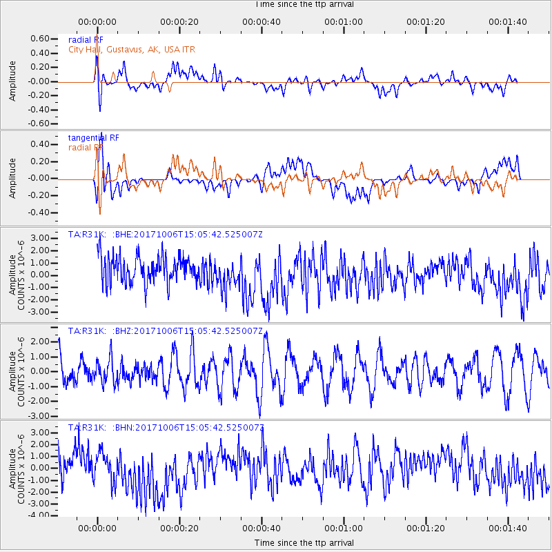
R31K City Hall, Gustavus, AK, USA - Earthquake Result Viewer
*The percent match for this event was below the threshold and hence no stack was calculated.
| Earthquake location: |
Near East Coast Of Honshu, Japan |
| Earthquake latitude/longitude: |
37.1/141.2 |
| Earthquake time(UTC): |
2017/10/06 (279) 14:56:40 GMT |
| Earthquake Depth: |
47 km |
| Earthquake Magnitude: |
5.4 Mww |
| Earthquake Catalog/Contributor: |
NEIC PDE/us |
|
| Network: |
TA USArray Transportable Network (new EarthScope stations) |
| Station: |
R31K City Hall, Gustavus, AK, USA |
| Lat/Lon: |
58.41 N/135.74 W |
| Elevation: |
15 m |
|
| Distance: |
55.8 deg |
| Az: |
39.156 deg |
| Baz: |
286.429 deg |
| Ray Param: |
$rayparam |
*The percent match for this event was below the threshold and hence was not used in the summary stack. |
|
| Radial Match: |
51.04399 % |
| Radial Bump: |
400 |
| Transverse Match: |
37.723545 % |
| Transverse Bump: |
400 |
| SOD ConfigId: |
13570011 |
| Insert Time: |
2019-04-28 22:54:48.649 +0000 |
| GWidth: |
2.5 |
| Max Bumps: |
400 |
| Tol: |
0.001 |
|
Signal To Noise
| Channel | StoN | STA | LTA |
| TA:R31K: :BHZ:20171006T15:05:42.525007Z | 0.6876951 | 8.211067E-7 | 1.1939983E-6 |
| TA:R31K: :BHN:20171006T15:05:42.525007Z | 1.1806813 | 1.2541203E-6 | 1.0622006E-6 |
| TA:R31K: :BHE:20171006T15:05:42.525007Z | 1.2026105 | 1.2610132E-6 | 1.0485633E-6 |
| Arrivals |
| Ps | |
| PpPs | |
| PsPs/PpSs | |


