You are here: Home > Network List > TA - USArray Transportable Network (new EarthScope stations) Stations List
> Station D15A Lincoln, MT, USA > Earthquake Result Viewer
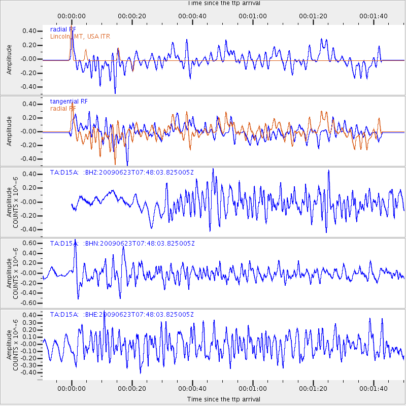
D15A Lincoln, MT, USA - Earthquake Result Viewer
*The percent match for this event was below the threshold and hence no stack was calculated.
| Earthquake location: |
Near East Coast Of Honshu, Japan |
| Earthquake latitude/longitude: |
38.8/142.4 |
| Earthquake time(UTC): |
2009/06/23 (174) 07:37:17 GMT |
| Earthquake Depth: |
37 km |
| Earthquake Magnitude: |
5.7 MB, 5.0 MS, 5.6 MW, 5.6 MW |
| Earthquake Catalog/Contributor: |
WHDF/NEIC |
|
| Network: |
TA USArray Transportable Network (new EarthScope stations) |
| Station: |
D15A Lincoln, MT, USA |
| Lat/Lon: |
47.04 N/112.52 W |
| Elevation: |
1593 m |
|
| Distance: |
71.5 deg |
| Az: |
44.121 deg |
| Baz: |
307.36 deg |
| Ray Param: |
$rayparam |
*The percent match for this event was below the threshold and hence was not used in the summary stack. |
|
| Radial Match: |
64.9346 % |
| Radial Bump: |
400 |
| Transverse Match: |
56.93513 % |
| Transverse Bump: |
400 |
| SOD ConfigId: |
2648 |
| Insert Time: |
2010-03-06 05:05:04.264 +0000 |
| GWidth: |
2.5 |
| Max Bumps: |
400 |
| Tol: |
0.001 |
|
Signal To Noise
| Channel | StoN | STA | LTA |
| TA:D15A: :BHN:20090623T07:48:03.825005Z | 3.4943802 | 2.7772558E-7 | 7.947778E-8 |
| TA:D15A: :BHE:20090623T07:48:03.825005Z | 1.9760807 | 1.6973632E-7 | 8.589545E-8 |
| TA:D15A: :BHZ:20090623T07:48:03.825005Z | 2.6478748 | 1.8725522E-7 | 7.071906E-8 |
| Arrivals |
| Ps | |
| PpPs | |
| PsPs/PpSs | |


