You are here: Home > Network List > CI - Caltech Regional Seismic Network Stations List
> Station SMM Simmler, CA, USA > Earthquake Result Viewer
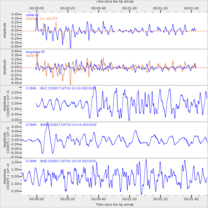
SMM Simmler, CA, USA - Earthquake Result Viewer
*The percent match for this event was below the threshold and hence no stack was calculated.
| Earthquake location: |
Santa Cruz Islands Region |
| Earthquake latitude/longitude: |
-11.0/164.5 |
| Earthquake time(UTC): |
2008/07/19 (201) 09:27:01 GMT |
| Earthquake Depth: |
11 km |
| Earthquake Magnitude: |
6.1 MB, 6.4 MS, 6.6 MW, 6.6 MW |
| Earthquake Catalog/Contributor: |
WHDF/NEIC |
|
| Network: |
CI Caltech Regional Seismic Network |
| Station: |
SMM Simmler, CA, USA |
| Lat/Lon: |
35.31 N/120.00 W |
| Elevation: |
599 m |
|
| Distance: |
84.8 deg |
| Az: |
52.668 deg |
| Baz: |
252.65 deg |
| Ray Param: |
$rayparam |
*The percent match for this event was below the threshold and hence was not used in the summary stack. |
|
| Radial Match: |
78.546616 % |
| Radial Bump: |
400 |
| Transverse Match: |
69.544754 % |
| Transverse Bump: |
400 |
| SOD ConfigId: |
2658 |
| Insert Time: |
2010-02-26 01:31:28.590 +0000 |
| GWidth: |
2.5 |
| Max Bumps: |
400 |
| Tol: |
0.001 |
|
Signal To Noise
| Channel | StoN | STA | LTA |
| CI:SMM: :BHN:20080719T09:39:04.082009Z | 9.950557 | 2.7283772E-6 | 2.741934E-7 |
| CI:SMM: :BHE:20080719T09:39:04.082009Z | 2.0860007 | 8.412107E-7 | 4.0326486E-7 |
| CI:SMM: :BHZ:20080719T09:39:04.082009Z | 2.0277495 | 1.1035015E-6 | 5.4420013E-7 |
| Arrivals |
| Ps | |
| PpPs | |
| PsPs/PpSs | |


