You are here: Home > Network List > TA - USArray Transportable Network (new EarthScope stations) Stations List
> Station D15A Lincoln, MT, USA > Earthquake Result Viewer
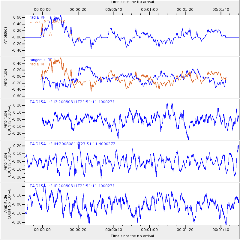
D15A Lincoln, MT, USA - Earthquake Result Viewer
*The percent match for this event was below the threshold and hence no stack was calculated.
| Earthquake location: |
Central Mid-Atlantic Ridge |
| Earthquake latitude/longitude: |
-1.0/-21.8 |
| Earthquake time(UTC): |
2008/08/11 (224) 23:38:38 GMT |
| Earthquake Depth: |
13 km |
| Earthquake Magnitude: |
6.0 MW, 5.2 MS, 5.4 MB, 6.0 MW |
| Earthquake Catalog/Contributor: |
WHDF/NEIC |
|
| Network: |
TA USArray Transportable Network (new EarthScope stations) |
| Station: |
D15A Lincoln, MT, USA |
| Lat/Lon: |
47.04 N/112.52 W |
| Elevation: |
1593 m |
|
| Distance: |
91.2 deg |
| Az: |
316.842 deg |
| Baz: |
90.199 deg |
| Ray Param: |
$rayparam |
*The percent match for this event was below the threshold and hence was not used in the summary stack. |
|
| Radial Match: |
55.38023 % |
| Radial Bump: |
400 |
| Transverse Match: |
42.620007 % |
| Transverse Bump: |
400 |
| SOD ConfigId: |
2504 |
| Insert Time: |
2010-03-06 05:05:41.325 +0000 |
| GWidth: |
2.5 |
| Max Bumps: |
400 |
| Tol: |
0.001 |
|
Signal To Noise
| Channel | StoN | STA | LTA |
| TA:D15A: :BHN:20080811T23:51:11.400027Z | 1.1460979 | 4.7170044E-8 | 4.1157083E-8 |
| TA:D15A: :BHE:20080811T23:51:11.400027Z | 2.2514281 | 1.4351693E-7 | 6.374484E-8 |
| TA:D15A: :BHZ:20080811T23:51:11.400027Z | 0.80997634 | 4.7960608E-8 | 5.9212358E-8 |
| Arrivals |
| Ps | |
| PpPs | |
| PsPs/PpSs | |


