You are here: Home > Network List > AU - Australian Seismological Centre Stations List
> Station ARMA Armidale, New South Wales > Earthquake Result Viewer
ARMA Armidale, New South Wales - Earthquake Result Viewer
| Earthquake location: |
Balleny Islands Region |
| Earthquake latitude/longitude: |
-61.7/154.6 |
| Earthquake time(UTC): |
2017/10/08 (281) 20:48:58 GMT |
| Earthquake Depth: |
10 km |
| Earthquake Magnitude: |
6.3 Mww |
| Earthquake Catalog/Contributor: |
NEIC PDE/us |
|
| Network: |
AU Australian Seismological Centre |
| Station: |
ARMA Armidale, New South Wales |
| Lat/Lon: |
30.42 S/151.63 E |
| Elevation: |
1112 m |
|
| Distance: |
31.4 deg |
| Az: |
355.148 deg |
| Baz: |
177.329 deg |
| Ray Param: |
0.07908179 |
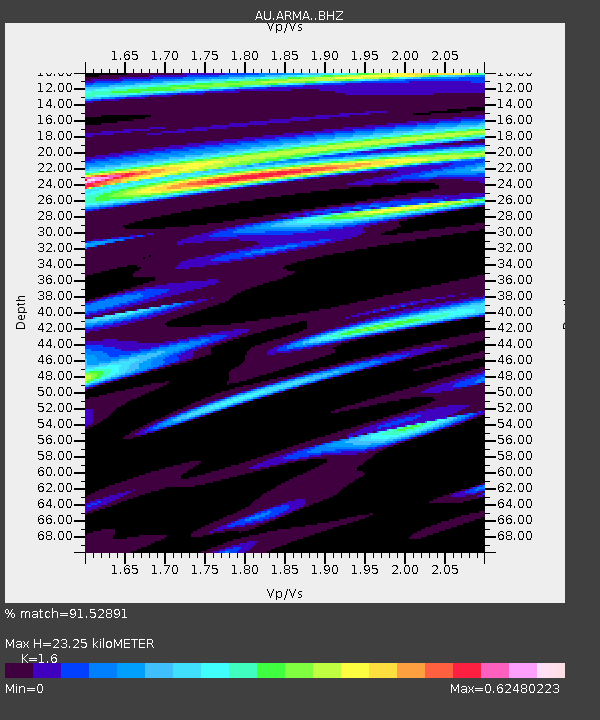
| Estimated Moho Depth: |
23.25 km |
| Estimated Crust Vp/Vs: |
1.60 |
| Assumed Crust Vp: |
6.577 km/s |
| Estimated Crust Vs: |
4.11 km/s |
| Estimated Crust Poisson's Ratio: |
0.18 |
|
| Radial Match: |
91.52891 % |
| Radial Bump: |
400 |
| Transverse Match: |
76.487404 % |
| Transverse Bump: |
400 |
| SOD ConfigId: |
13570011 |
| Insert Time: |
2019-04-28 23:07:42.329 +0000 |
| GWidth: |
2.5 |
| Max Bumps: |
400 |
| Tol: |
0.001 |
|

Signal To Noise
| Channel | StoN | STA | LTA |
| AU:ARMA: :BHZ:20171008T20:54:49.019011Z | 11.837163 | 2.1224225E-6 | 1.7930162E-7 |
| AU:ARMA: :BHN:20171008T20:54:49.019011Z | 8.502651 | 1.3808715E-6 | 1.6240482E-7 |
| AU:ARMA: :BHE:20171008T20:54:49.019011Z | 2.04832 | 3.91765E-7 | 1.9126162E-7 |
| Arrivals |
| Ps | 2.3 SECOND |
| PpPs | 8.4 SECOND |
| PsPs/PpSs | 11 SECOND |


