You are here: Home > Network List > AU - Australian Seismological Centre Stations List
> Station WRKA Warrakurna, Western Australia > Earthquake Result Viewer
WRKA Warrakurna, Western Australia - Earthquake Result Viewer
| Earthquake location: |
Balleny Islands Region |
| Earthquake latitude/longitude: |
-61.7/154.6 |
| Earthquake time(UTC): |
2017/10/08 (281) 20:48:58 GMT |
| Earthquake Depth: |
10 km |
| Earthquake Magnitude: |
6.3 Mww |
| Earthquake Catalog/Contributor: |
NEIC PDE/us |
|
| Network: |
AU Australian Seismological Centre |
| Station: |
WRKA Warrakurna, Western Australia |
| Lat/Lon: |
25.04 S/128.30 E |
| Elevation: |
622 m |
|
| Distance: |
40.8 deg |
| Az: |
322.084 deg |
| Baz: |
161.193 deg |
| Ray Param: |
0.07420417 |
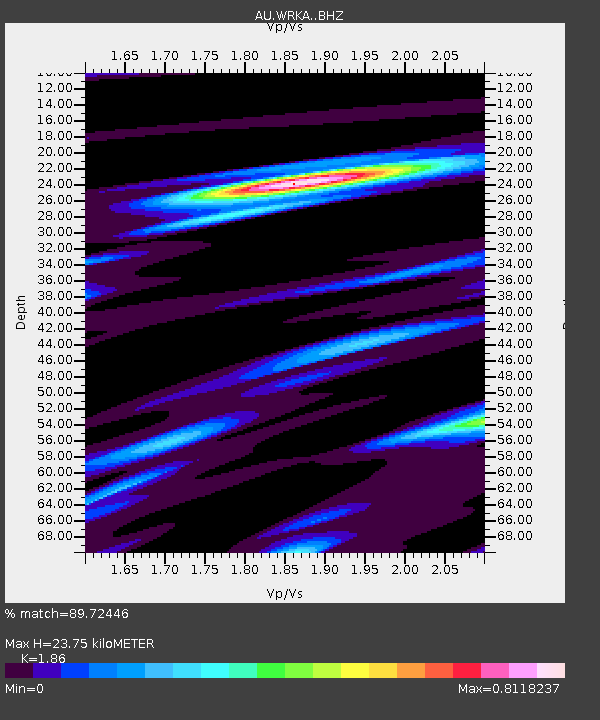
| Estimated Moho Depth: |
23.75 km |
| Estimated Crust Vp/Vs: |
1.86 |
| Assumed Crust Vp: |
6.51 km/s |
| Estimated Crust Vs: |
3.5 km/s |
| Estimated Crust Poisson's Ratio: |
0.30 |
|
| Radial Match: |
89.72446 % |
| Radial Bump: |
221 |
| Transverse Match: |
66.77649 % |
| Transverse Bump: |
400 |
| SOD ConfigId: |
13570011 |
| Insert Time: |
2019-04-28 23:07:52.531 +0000 |
| GWidth: |
2.5 |
| Max Bumps: |
400 |
| Tol: |
0.001 |
|

Signal To Noise
| Channel | StoN | STA | LTA |
| AU:WRKA: :BHZ:20171008T20:56:09.068999Z | 4.8001695 | 1.6929043E-6 | 3.5267595E-7 |
| AU:WRKA: :BHN:20171008T20:56:09.068999Z | 8.583836 | 1.0712762E-6 | 1.2480159E-7 |
| AU:WRKA: :BHE:20171008T20:56:09.068999Z | 2.1888843 | 5.8433983E-7 | 2.6695784E-7 |
| Arrivals |
| Ps | 3.4 SECOND |
| PpPs | 9.7 SECOND |
| PsPs/PpSs | 13 SECOND |


