G14A Jackson, MT, USA - Earthquake Result Viewer
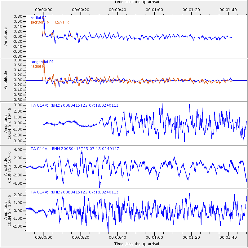
Earthquake location: Andreanof Islands, Aleutian Is.
Earthquake latitude/longitude: 51.9/-179.4
Earthquake time(UTC): 2008/04/15 (106) 22:59:51 GMT
Earthquake Depth: 10 km
Earthquake Magnitude: 6.1 MB, 6.4 MS, 6.4 MW, 6.4 MW
Earthquake Catalog/Contributor: WHDF/NEIC
Network: TA USArray Transportable Network (new EarthScope stations)
Station: G14A Jackson, MT, USA
Lat/Lon: 45.24 N/113.46 W
Elevation: 2140 m
Distance: 42.8 deg
Az: 71.75 deg
Baz: 303.513 deg
Ray Param: 0.07297722
Estimated Moho Depth: 33.5 km
Estimated Crust Vp/Vs: 1.95
Assumed Crust Vp: 6.577 km/s
Estimated Crust Vs: 3.377 km/s
Estimated Crust Poisson's Ratio: 0.32
Radial Match: 89.278824 %
Radial Bump: 400
Transverse Match: 74.2039 %
Transverse Bump: 400
SOD ConfigId: 2504
Insert Time: 2010-03-06 05:05:49.384 +0000
GWidth: 2.5
Max Bumps: 400
Tol: 0.001

Signal To Noise

ChannelStoNSTALTA
TA:G14A: :BHN:20080415T23:07:18.024011Z4.56609447.7212E-71.6909857E-7
TA:G14A: :BHE:20080415T23:07:18.024011Z1.51965583.3329593E-72.1932331E-7
TA:G14A: :BHZ:20080415T23:07:18.024011Z1.6531194.4304298E-72.680043E-7
Arrivals
Ps5.1 SECOND
PpPs14 SECOND
PsPs/PpSs19 SECOND