You are here: Home > Network List > CI - Caltech Regional Seismic Network Stations List
> Station SMM Simmler, CA, USA > Earthquake Result Viewer
SMM Simmler, CA, USA - Earthquake Result Viewer
*The percent match for this event was below the threshold and hence no stack was calculated.
| Earthquake location: |
Tonga Islands |
| Earthquake latitude/longitude: |
-15.2/-174.2 |
| Earthquake time(UTC): |
2008/11/08 (313) 09:15:51 GMT |
| Earthquake Depth: |
140 km |
| Earthquake Magnitude: |
5.5 MW, 5.3 MB |
| Earthquake Catalog/Contributor: |
WHDF/NEIC |
|
| Network: |
CI Caltech Regional Seismic Network |
| Station: |
SMM Simmler, CA, USA |
| Lat/Lon: |
35.31 N/120.00 W |
| Elevation: |
599 m |
|
| Distance: |
71.8 deg |
| Az: |
44.281 deg |
| Baz: |
235.502 deg |
| Ray Param: |
$rayparam |
*The percent match for this event was below the threshold and hence was not used in the summary stack. |
|
| Radial Match: |
64.02684 % |
| Radial Bump: |
400 |
| Transverse Match: |
61.480602 % |
| Transverse Bump: |
400 |
| SOD ConfigId: |
2658 |
| Insert Time: |
2010-02-26 01:31:30.432 +0000 |
| GWidth: |
2.5 |
| Max Bumps: |
400 |
| Tol: |
0.001 |
|
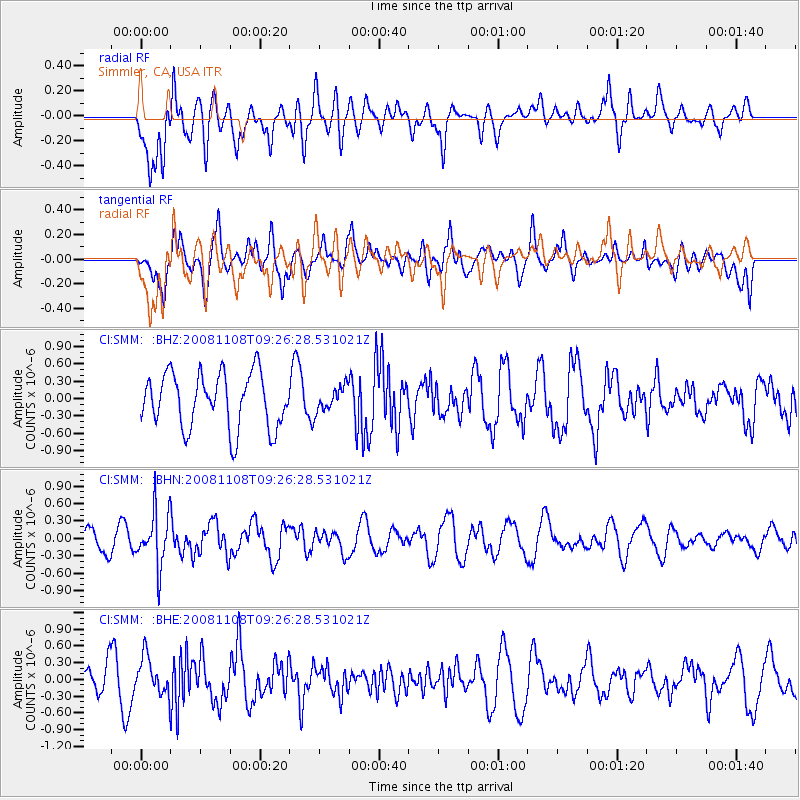
Signal To Noise
| Channel | StoN | STA | LTA |
| CI:SMM: :BHN:20081108T09:26:28.531021Z | 2.0993118 | 4.62683E-7 | 2.2039745E-7 |
| CI:SMM: :BHE:20081108T09:26:28.531021Z | 1.0069426 | 3.3806776E-7 | 3.3573687E-7 |
| CI:SMM: :BHZ:20081108T09:26:28.531021Z | 0.44399387 | 2.100253E-7 | 4.730365E-7 |
| Arrivals |
| Ps | |
| PpPs | |
| PsPs/PpSs | |


