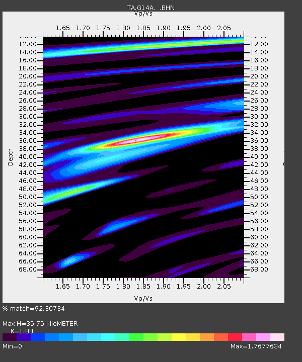
G14A Jackson, MT, USA - Earthquake Result Viewer
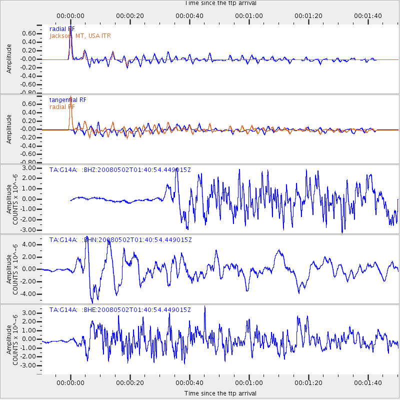
Earthquake location: Andreanof Islands, Aleutian Is.
Earthquake latitude/longitude: 51.9/-177.5
Earthquake time(UTC): 2008/05/02 (123) 01:33:37 GMT
Earthquake Depth: 14 km
Earthquake Magnitude: 6.3 MB, 6.8 MS, 6.6 MW, 6.6 MW
Earthquake Catalog/Contributor: WHDF/NEIC
Network: TA USArray Transportable Network (new EarthScope stations)
Station: G14A Jackson, MT, USA
Lat/Lon: 45.24 N/113.46 W
Elevation: 2140 m
Distance: 41.7 deg
Az: 72.816 deg
Baz: 303.013 deg
Ray Param: 0.07362545
Estimated Moho Depth: 35.75 km
Estimated Crust Vp/Vs: 1.83
Assumed Crust Vp: 6.577 km/s
Estimated Crust Vs: 3.594 km/s
Estimated Crust Poisson's Ratio: 0.29
Radial Match: 92.30734 %
Radial Bump: 400
Transverse Match: 80.24531 %
Transverse Bump: 400
SOD ConfigId: 2504
Insert Time: 2010-03-06 05:05:52.265 +0000
GWidth: 2.5
Max Bumps: 400
Tol: 0.001

Signal To Noise

ChannelStoNSTALTA
TA:G14A: :BHN:20080502T01:40:54.449015Z10.9706819.639218E-78.786345E-8
TA:G14A: :BHE:20080502T01:40:54.449015Z2.286553.2407164E-71.4172952E-7
TA:G14A: :BHZ:20080502T01:40:54.449015Z4.54314476.97719E-71.5357622E-7
Arrivals
Ps4.8 SECOND
PpPs14 SECOND
PsPs/PpSs19 SECOND