You are here: Home > Network List > 5H - Central Virginia and South Carolina seismic monitoring experiment Stations List
> Station DAVE Dillwyn, VA > Earthquake Result Viewer
DAVE Dillwyn, VA - Earthquake Result Viewer
| Earthquake location: |
Rat Islands, Aleutian Islands |
| Earthquake latitude/longitude: |
52.4/176.8 |
| Earthquake time(UTC): |
2017/10/08 (281) 22:34:33 GMT |
| Earthquake Depth: |
112 km |
| Earthquake Magnitude: |
6.6 mww |
| Earthquake Catalog/Contributor: |
NEIC PDE/us |
|
| Network: |
5H Central Virginia and South Carolina seismic monitoring experiment |
| Station: |
DAVE Dillwyn, VA |
| Lat/Lon: |
37.55 N/78.37 W |
| Elevation: |
130 m |
|
| Distance: |
69.2 deg |
| Az: |
55.289 deg |
| Baz: |
320.727 deg |
| Ray Param: |
0.055531543 |
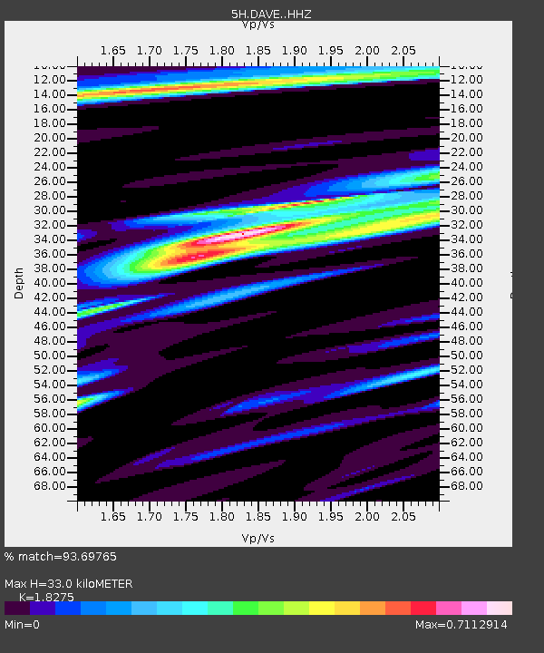
| Estimated Moho Depth: |
33.0 km |
| Estimated Crust Vp/Vs: |
1.83 |
| Assumed Crust Vp: |
6.419 km/s |
| Estimated Crust Vs: |
3.513 km/s |
| Estimated Crust Poisson's Ratio: |
0.29 |
|
| Radial Match: |
93.69765 % |
| Radial Bump: |
387 |
| Transverse Match: |
60.283375 % |
| Transverse Bump: |
400 |
| SOD ConfigId: |
13570011 |
| Insert Time: |
2019-04-28 23:09:20.545 +0000 |
| GWidth: |
2.5 |
| Max Bumps: |
400 |
| Tol: |
0.001 |
|

Signal To Noise
| Channel | StoN | STA | LTA |
| 5H:DAVE: :HHZ:20171008T22:44:57.57499Z | 29.81166 | 3.6502502E-6 | 1.2244371E-7 |
| 5H:DAVE: :HHN:20171008T22:44:57.57499Z | 10.329532 | 1.1655047E-6 | 1.128323E-7 |
| 5H:DAVE: :HHE:20171008T22:44:57.57499Z | 8.863102 | 8.727117E-7 | 9.846572E-8 |
| Arrivals |
| Ps | 4.4 SECOND |
| PpPs | 14 SECOND |
| PsPs/PpSs | 18 SECOND |


