You are here: Home > Network List > 5H - Central Virginia and South Carolina seismic monitoring experiment Stations List
> Station NORA Yanceyville, VA > Earthquake Result Viewer
NORA Yanceyville, VA - Earthquake Result Viewer
| Earthquake location: |
Rat Islands, Aleutian Islands |
| Earthquake latitude/longitude: |
52.4/176.8 |
| Earthquake time(UTC): |
2017/10/08 (281) 22:34:33 GMT |
| Earthquake Depth: |
112 km |
| Earthquake Magnitude: |
6.6 mww |
| Earthquake Catalog/Contributor: |
NEIC PDE/us |
|
| Network: |
5H Central Virginia and South Carolina seismic monitoring experiment |
| Station: |
NORA Yanceyville, VA |
| Lat/Lon: |
37.92 N/77.98 W |
| Elevation: |
133 m |
|
| Distance: |
69.1 deg |
| Az: |
54.785 deg |
| Baz: |
320.783 deg |
| Ray Param: |
0.05559194 |
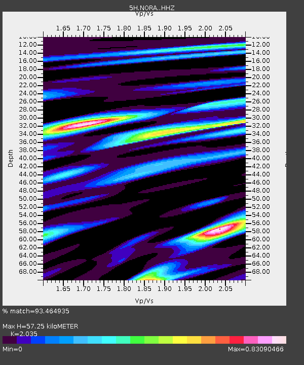
| Estimated Moho Depth: |
57.25 km |
| Estimated Crust Vp/Vs: |
2.04 |
| Assumed Crust Vp: |
6.565 km/s |
| Estimated Crust Vs: |
3.226 km/s |
| Estimated Crust Poisson's Ratio: |
0.34 |
|
| Radial Match: |
93.464935 % |
| Radial Bump: |
400 |
| Transverse Match: |
76.03106 % |
| Transverse Bump: |
400 |
| SOD ConfigId: |
13570011 |
| Insert Time: |
2019-04-28 23:09:29.605 +0000 |
| GWidth: |
2.5 |
| Max Bumps: |
400 |
| Tol: |
0.001 |
|

Signal To Noise
| Channel | StoN | STA | LTA |
| 5H:NORA: :HHZ:20171008T22:44:57.014993Z | 16.318869 | 3.7234943E-6 | 2.2817112E-7 |
| 5H:NORA: :HHN:20171008T22:44:57.014993Z | 13.244973 | 1.3976841E-6 | 1.0552563E-7 |
| 5H:NORA: :HHE:20171008T22:44:57.014993Z | 6.458002 | 6.819046E-7 | 1.0559065E-7 |
| Arrivals |
| Ps | 9.3 SECOND |
| PpPs | 26 SECOND |
| PsPs/PpSs | 35 SECOND |


