You are here: Home > Network List > AU - Australian Seismological Centre Stations List
> Station ARMA Armidale, New South Wales > Earthquake Result Viewer
ARMA Armidale, New South Wales - Earthquake Result Viewer
| Earthquake location: |
Rat Islands, Aleutian Islands |
| Earthquake latitude/longitude: |
52.4/176.8 |
| Earthquake time(UTC): |
2017/10/08 (281) 22:34:33 GMT |
| Earthquake Depth: |
112 km |
| Earthquake Magnitude: |
6.6 mww |
| Earthquake Catalog/Contributor: |
NEIC PDE/us |
|
| Network: |
AU Australian Seismological Centre |
| Station: |
ARMA Armidale, New South Wales |
| Lat/Lon: |
30.42 S/151.63 E |
| Elevation: |
1112 m |
|
| Distance: |
85.4 deg |
| Az: |
201.635 deg |
| Baz: |
15.143 deg |
| Ray Param: |
0.0445436 |
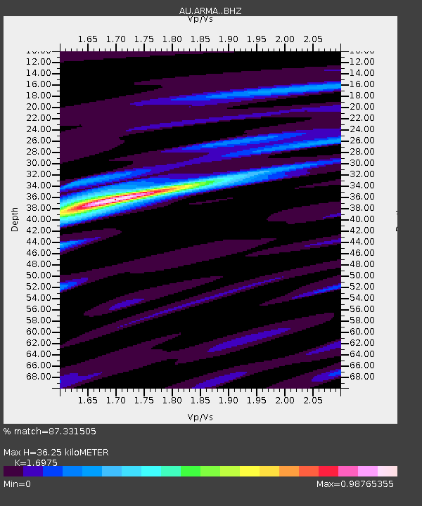
| Estimated Moho Depth: |
36.25 km |
| Estimated Crust Vp/Vs: |
1.70 |
| Assumed Crust Vp: |
6.577 km/s |
| Estimated Crust Vs: |
3.874 km/s |
| Estimated Crust Poisson's Ratio: |
0.23 |
|
| Radial Match: |
87.331505 % |
| Radial Bump: |
307 |
| Transverse Match: |
78.26415 % |
| Transverse Bump: |
350 |
| SOD ConfigId: |
13570011 |
| Insert Time: |
2019-04-28 23:09:43.893 +0000 |
| GWidth: |
2.5 |
| Max Bumps: |
400 |
| Tol: |
0.001 |
|

Signal To Noise
| Channel | StoN | STA | LTA |
| AU:ARMA: :BHZ:20171008T22:46:27.769021Z | 17.054783 | 4.0883833E-6 | 2.3972063E-7 |
| AU:ARMA: :BHN:20171008T22:46:27.769021Z | 8.693173 | 1.5966035E-6 | 1.8366177E-7 |
| AU:ARMA: :BHE:20171008T22:46:27.769021Z | 2.3865726 | 5.4507746E-7 | 2.2839339E-7 |
| Arrivals |
| Ps | 3.9 SECOND |
| PpPs | 14 SECOND |
| PsPs/PpSs | 18 SECOND |


