You are here: Home > Network List > CI - Caltech Regional Seismic Network Stations List
> Station SMM Simmler, CA, USA > Earthquake Result Viewer
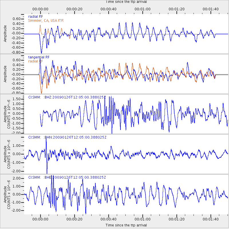
SMM Simmler, CA, USA - Earthquake Result Viewer
*The percent match for this event was below the threshold and hence no stack was calculated.
| Earthquake location: |
Fiji Islands Region |
| Earthquake latitude/longitude: |
-17.8/-178.6 |
| Earthquake time(UTC): |
2009/01/26 (026) 11:54:39 GMT |
| Earthquake Depth: |
580 km |
| Earthquake Magnitude: |
5.5 MB, 5.8 MW, 5.8 MW |
| Earthquake Catalog/Contributor: |
WHDF/NEIC |
|
| Network: |
CI Caltech Regional Seismic Network |
| Station: |
SMM Simmler, CA, USA |
| Lat/Lon: |
35.31 N/120.00 W |
| Elevation: |
599 m |
|
| Distance: |
76.6 deg |
| Az: |
45.845 deg |
| Baz: |
236.701 deg |
| Ray Param: |
$rayparam |
*The percent match for this event was below the threshold and hence was not used in the summary stack. |
|
| Radial Match: |
61.674694 % |
| Radial Bump: |
400 |
| Transverse Match: |
63.228577 % |
| Transverse Bump: |
400 |
| SOD ConfigId: |
2658 |
| Insert Time: |
2010-02-26 01:31:31.946 +0000 |
| GWidth: |
2.5 |
| Max Bumps: |
400 |
| Tol: |
0.001 |
|
Signal To Noise
| Channel | StoN | STA | LTA |
| CI:SMM: :BHN:20090126T12:05:00.388025Z | 2.4804354 | 7.664811E-7 | 3.090107E-7 |
| CI:SMM: :BHE:20090126T12:05:00.388025Z | 1.1897364 | 7.0932606E-7 | 5.962044E-7 |
| CI:SMM: :BHZ:20090126T12:05:00.388025Z | 2.2771018 | 1.0295508E-6 | 4.5213213E-7 |
| Arrivals |
| Ps | |
| PpPs | |
| PsPs/PpSs | |


