You are here: Home > Network List > TA - USArray Transportable Network (new EarthScope stations) Stations List
> Station G14A Jackson, MT, USA > Earthquake Result Viewer
G14A Jackson, MT, USA - Earthquake Result Viewer
| Earthquake location: |
Tonga Islands |
| Earthquake latitude/longitude: |
-21.9/-173.8 |
| Earthquake time(UTC): |
2008/10/19 (293) 05:10:33 GMT |
| Earthquake Depth: |
29 km |
| Earthquake Magnitude: |
6.8 MB, 7.0 MS, 6.9 MW, 6.9 MW |
| Earthquake Catalog/Contributor: |
WHDF/NEIC |
|
| Network: |
TA USArray Transportable Network (new EarthScope stations) |
| Station: |
G14A Jackson, MT, USA |
| Lat/Lon: |
45.24 N/113.46 W |
| Elevation: |
2140 m |
|
| Distance: |
86.4 deg |
| Az: |
37.969 deg |
| Baz: |
233.994 deg |
| Ray Param: |
0.04403473 |
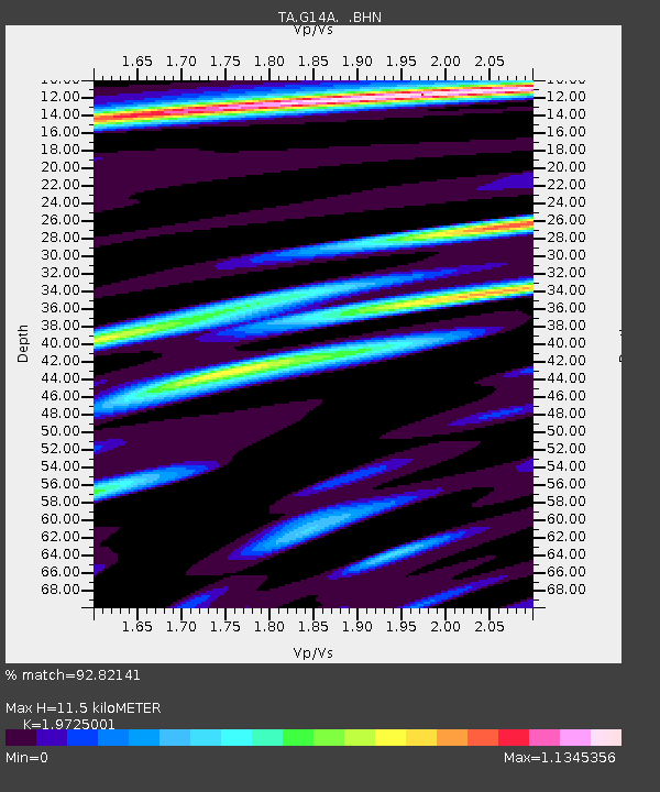
| Estimated Moho Depth: |
11.5 km |
| Estimated Crust Vp/Vs: |
1.97 |
| Assumed Crust Vp: |
6.577 km/s |
| Estimated Crust Vs: |
3.334 km/s |
| Estimated Crust Poisson's Ratio: |
0.33 |
|
| Radial Match: |
92.82141 % |
| Radial Bump: |
400 |
| Transverse Match: |
86.82615 % |
| Transverse Bump: |
400 |
| SOD ConfigId: |
2556 |
| Insert Time: |
2010-03-06 05:06:22.276 +0000 |
| GWidth: |
2.5 |
| Max Bumps: |
400 |
| Tol: |
0.001 |
|
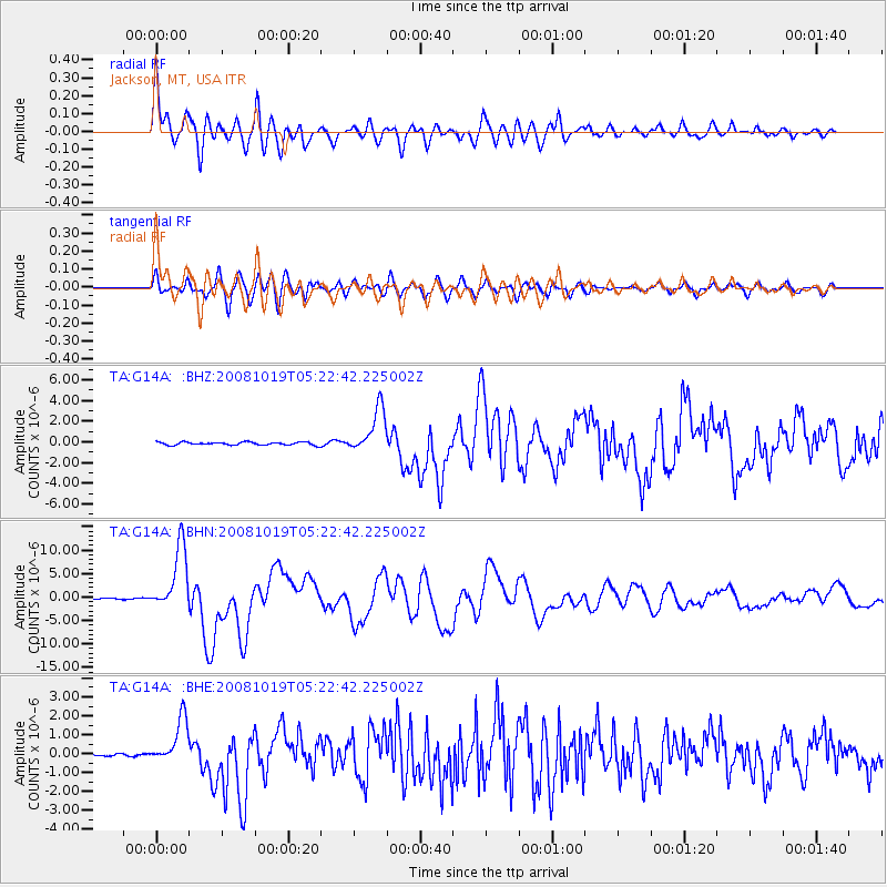
Signal To Noise
| Channel | StoN | STA | LTA |
| TA:G14A: :BHN:20081019T05:22:42.225002Z | 39.49643 | 6.9212606E-6 | 1.7523763E-7 |
| TA:G14A: :BHE:20081019T05:22:42.225002Z | 11.367386 | 1.2113018E-6 | 1.0655939E-7 |
| TA:G14A: :BHZ:20081019T05:22:42.225002Z | 15.131183 | 2.1511191E-6 | 1.4216464E-7 |
| Arrivals |
| Ps | 1.7 SECOND |
| PpPs | 5.1 SECOND |
| PsPs/PpSs | 6.8 SECOND |


