You are here: Home > Network List > BE - Belgian Seismic Network Stations List
> Station RCHB Rochefort, Belgium > Earthquake Result Viewer
RCHB Rochefort, Belgium - Earthquake Result Viewer
| Earthquake location: |
Rat Islands, Aleutian Islands |
| Earthquake latitude/longitude: |
52.4/176.8 |
| Earthquake time(UTC): |
2017/10/08 (281) 22:34:33 GMT |
| Earthquake Depth: |
112 km |
| Earthquake Magnitude: |
6.6 mww |
| Earthquake Catalog/Contributor: |
NEIC PDE/us |
|
| Network: |
BE Belgian Seismic Network |
| Station: |
RCHB Rochefort, Belgium |
| Lat/Lon: |
50.16 N/5.23 E |
| Elevation: |
191 m |
|
| Distance: |
77.5 deg |
| Az: |
354.464 deg |
| Baz: |
5.267 deg |
| Ray Param: |
0.05000342 |
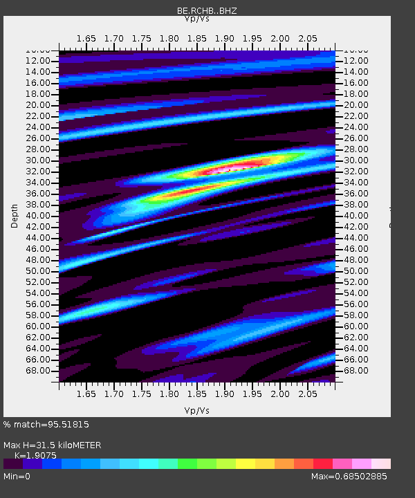
| Estimated Moho Depth: |
31.5 km |
| Estimated Crust Vp/Vs: |
1.91 |
| Assumed Crust Vp: |
6.276 km/s |
| Estimated Crust Vs: |
3.29 km/s |
| Estimated Crust Poisson's Ratio: |
0.31 |
|
| Radial Match: |
95.51815 % |
| Radial Bump: |
259 |
| Transverse Match: |
72.20581 % |
| Transverse Bump: |
400 |
| SOD ConfigId: |
13570011 |
| Insert Time: |
2019-04-28 23:10:17.937 +0000 |
| GWidth: |
2.5 |
| Max Bumps: |
400 |
| Tol: |
0.001 |
|

Signal To Noise
| Channel | StoN | STA | LTA |
| BE:RCHB: :BHZ:20171008T22:45:46.418984Z | 7.8284736 | 1.2146021E-6 | 1.5515185E-7 |
| BE:RCHB: :BHN:20171008T22:45:46.418984Z | 4.99897 | 5.1713386E-7 | 1.0344808E-7 |
| BE:RCHB: :BHE:20171008T22:45:46.418984Z | 1.2559016 | 1.1798871E-7 | 9.394742E-8 |
| Arrivals |
| Ps | 4.7 SECOND |
| PpPs | 14 SECOND |
| PsPs/PpSs | 19 SECOND |


