You are here: Home > Network List > CA - Catalan Seismic Network Stations List
> Station CFON Fontmartina > Earthquake Result Viewer
CFON Fontmartina - Earthquake Result Viewer
| Earthquake location: |
Rat Islands, Aleutian Islands |
| Earthquake latitude/longitude: |
52.4/176.8 |
| Earthquake time(UTC): |
2017/10/08 (281) 22:34:33 GMT |
| Earthquake Depth: |
112 km |
| Earthquake Magnitude: |
6.6 mww |
| Earthquake Catalog/Contributor: |
NEIC PDE/us |
|
| Network: |
CA Catalan Seismic Network |
| Station: |
CFON Fontmartina |
| Lat/Lon: |
41.76 N/2.43 E |
| Elevation: |
973 m |
|
| Distance: |
86.0 deg |
| Az: |
355.783 deg |
| Baz: |
3.449 deg |
| Ray Param: |
0.04409801 |
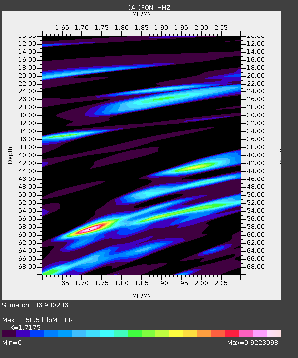
| Estimated Moho Depth: |
58.5 km |
| Estimated Crust Vp/Vs: |
1.72 |
| Assumed Crust Vp: |
5.88 km/s |
| Estimated Crust Vs: |
3.424 km/s |
| Estimated Crust Poisson's Ratio: |
0.24 |
|
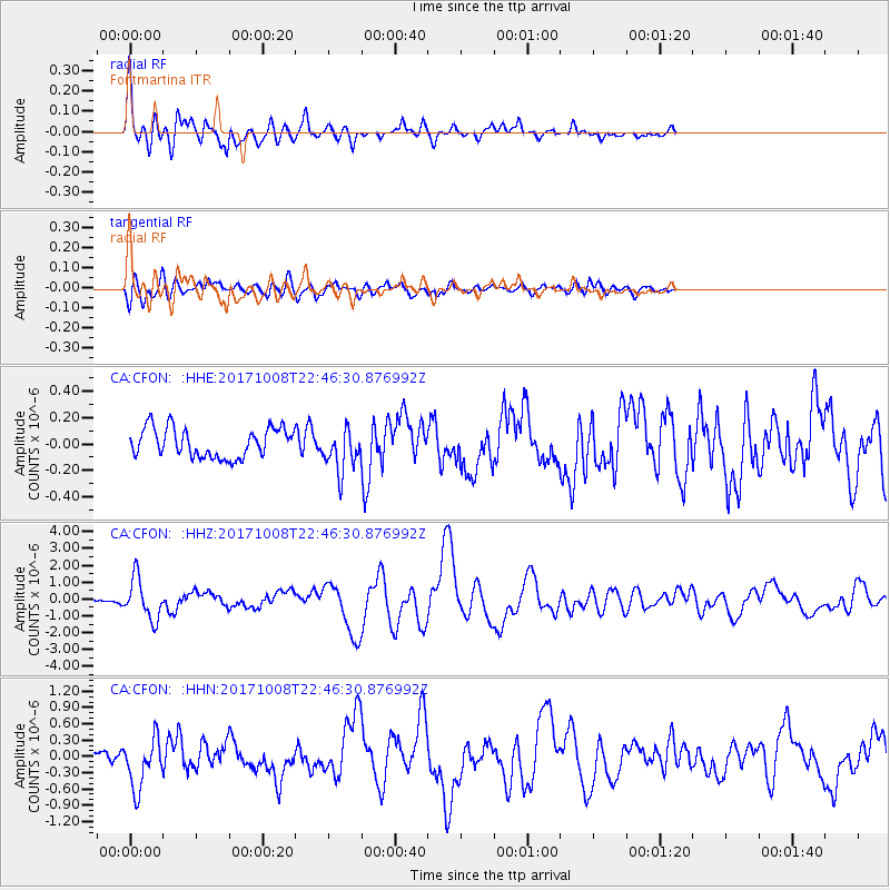
| Radial Match: |
86.980286 % |
| Radial Bump: |
400 |
| Transverse Match: |
72.380554 % |
| Transverse Bump: |
400 |
| SOD ConfigId: |
13570011 |
| Insert Time: |
2019-04-28 23:10:37.821 +0000 |
| GWidth: |
2.5 |
| Max Bumps: |
400 |
| Tol: |
0.001 |
|
Signal To Noise
| Channel | StoN | STA | LTA |
| CA:CFON: :HHZ:20171008T22:46:30.876992Z | 9.513736 | 1.2107698E-6 | 1.2726545E-7 |
| CA:CFON: :HHN:20171008T22:46:30.876992Z | 4.8663697 | 4.6141682E-7 | 9.481746E-8 |
| CA:CFON: :HHE:20171008T22:46:30.876992Z | 1.4545105 | 1.61172E-7 | 1.10808415E-7 |
| Arrivals |
| Ps | 7.3 SECOND |
| PpPs | 26 SECOND |
| PsPs/PpSs | 34 SECOND |


