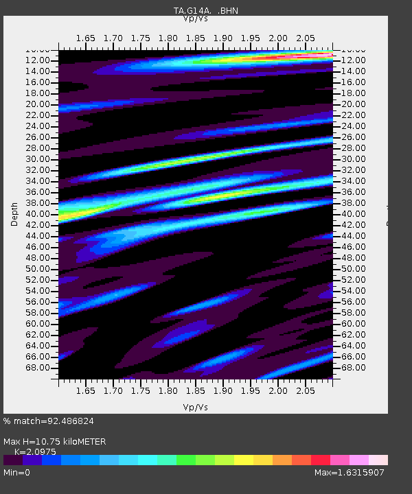
G14A Jackson, MT, USA - Earthquake Result Viewer
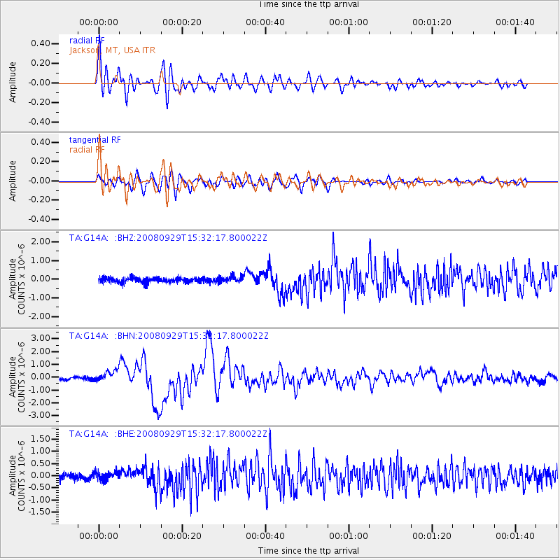
Earthquake location: Kermadec Islands, New Zealand
Earthquake latitude/longitude: -29.8/-177.7
Earthquake time(UTC): 2008/09/29 (273) 15:19:31 GMT
Earthquake Depth: 36 km
Earthquake Magnitude: 6.5 MB, 6.7 MS, 7.0 MW, 7.0 MW
Earthquake Catalog/Contributor: WHDF/NEIC
Network: TA USArray Transportable Network (new EarthScope stations)
Station: G14A Jackson, MT, USA
Lat/Lon: 45.24 N/113.46 W
Elevation: 2140 m
Distance: 94.7 deg
Az: 39.668 deg
Baz: 231.787 deg
Ray Param: 0.04095588
Estimated Moho Depth: 10.75 km
Estimated Crust Vp/Vs: 2.10
Assumed Crust Vp: 6.577 km/s
Estimated Crust Vs: 3.136 km/s
Estimated Crust Poisson's Ratio: 0.35
Radial Match: 92.486824 %
Radial Bump: 400
Transverse Match: 81.70945 %
Transverse Bump: 400
SOD ConfigId: 2560
Insert Time: 2010-03-06 05:06:30.355 +0000
GWidth: 2.5
Max Bumps: 400
Tol: 0.001

Signal To Noise

ChannelStoNSTALTA
TA:G14A: :BHN:20080929T15:32:17.800022Z3.70892214.453164E-71.2006626E-7
TA:G14A: :BHE:20080929T15:32:17.800022Z1.34755581.8120464E-71.3446913E-7
TA:G14A: :BHZ:20080929T15:32:17.800022Z1.30990151.7564201E-71.3408795E-7
Arrivals
Ps1.8 SECOND
PpPs5.0 SECOND
PsPs/PpSs6.8 SECOND