You are here: Home > Network List > TA - USArray Transportable Network (new EarthScope stations) Stations List
> Station G14A Jackson, MT, USA > Earthquake Result Viewer
G14A Jackson, MT, USA - Earthquake Result Viewer

| Earthquake location: |
East Of Kuril Islands |
| Earthquake latitude/longitude: |
46.9/155.2 |
| Earthquake time(UTC): |
2009/01/15 (015) 17:49:39 GMT |
| Earthquake Depth: |
36 km |
| Earthquake Magnitude: |
6.9 MB, 7.5 MS, 7.4 MW, 7.4 MW |
| Earthquake Catalog/Contributor: |
WHDF/NEIC |
|
| Network: |
TA USArray Transportable Network (new EarthScope stations) |
| Station: |
G14A Jackson, MT, USA |
| Lat/Lon: |
45.24 N/113.46 W |
| Elevation: |
2140 m |
|
| Distance: |
59.8 deg |
| Az: |
54.806 deg |
| Baz: |
307.456 deg |
| Ray Param: |
0.06188674 |
| Estimated Moho Depth: |
35.25 km |
| Estimated Crust Vp/Vs: |
1.91 |
| Assumed Crust Vp: |
6.577 km/s |
| Estimated Crust Vs: |
3.434 km/s |
| Estimated Crust Poisson's Ratio: |
0.31 |
|
| Radial Match: |
93.91724 % |
| Radial Bump: |
374 |
| Transverse Match: |
83.23184 % |
| Transverse Bump: |
400 |
| SOD ConfigId: |
2834 |
| Insert Time: |
2010-03-06 05:06:34.203 +0000 |
| GWidth: |
2.5 |
| Max Bumps: |
400 |
| Tol: |
0.001 |
|
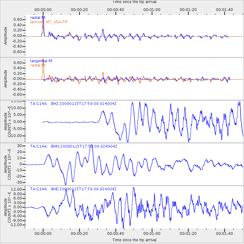
Signal To Noise
| Channel | StoN | STA | LTA |
| TA:G14A: :BHN:20090115T17:59:09.924004Z | 49.65985 | 9.467851E-6 | 1.9065403E-7 |
| TA:G14A: :BHE:20090115T17:59:09.924004Z | 8.883266 | 3.3405288E-6 | 3.7604738E-7 |
| TA:G14A: :BHZ:20090115T17:59:09.924004Z | 20.08067 | 4.6137643E-6 | 2.297615E-7 |
| Arrivals |
| Ps | 5.1 SECOND |
| PpPs | 15 SECOND |
| PsPs/PpSs | 20 SECOND |


