You are here: Home > Network List > CI - Caltech Regional Seismic Network Stations List
> Station TIN Tinemaha, Big Pine, CA, USA > Earthquake Result Viewer
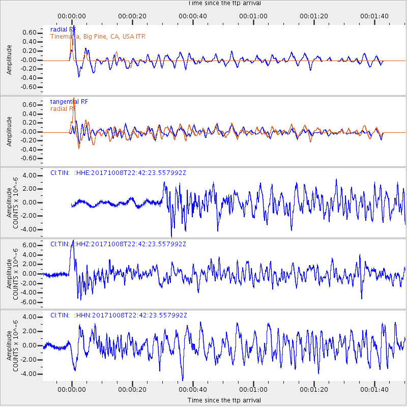
TIN Tinemaha, Big Pine, CA, USA - Earthquake Result Viewer
*The percent match for this event was below the threshold and hence no stack was calculated.
| Earthquake location: |
Rat Islands, Aleutian Islands |
| Earthquake latitude/longitude: |
52.4/176.8 |
| Earthquake time(UTC): |
2017/10/08 (281) 22:34:33 GMT |
| Earthquake Depth: |
112 km |
| Earthquake Magnitude: |
6.6 mww |
| Earthquake Catalog/Contributor: |
NEIC PDE/us |
|
| Network: |
CI Caltech Regional Seismic Network |
| Station: |
TIN Tinemaha, Big Pine, CA, USA |
| Lat/Lon: |
37.05 N/118.23 W |
| Elevation: |
1197 m |
|
| Distance: |
47.0 deg |
| Az: |
82.187 deg |
| Baz: |
310.718 deg |
| Ray Param: |
$rayparam |
*The percent match for this event was below the threshold and hence was not used in the summary stack. |
|
| Radial Match: |
69.16297 % |
| Radial Bump: |
400 |
| Transverse Match: |
64.063515 % |
| Transverse Bump: |
400 |
| SOD ConfigId: |
13570011 |
| Insert Time: |
2019-04-28 23:11:42.498 +0000 |
| GWidth: |
2.5 |
| Max Bumps: |
400 |
| Tol: |
0.001 |
|
Signal To Noise
| Channel | StoN | STA | LTA |
| CI:TIN: :HHZ:20171008T22:42:23.557992Z | 20.56062 | 3.7062175E-6 | 1.8025807E-7 |
| CI:TIN: :HHN:20171008T22:42:23.557992Z | 4.3990073 | 1.8097727E-6 | 4.1140478E-7 |
| CI:TIN: :HHE:20171008T22:42:23.557992Z | 5.960842 | 1.9418483E-6 | 3.2576745E-7 |
| Arrivals |
| Ps | |
| PpPs | |
| PsPs/PpSs | |


