You are here: Home > Network List > CN - Canadian National Seismograph Network Stations List
> Station A21 St-Andre, QC, CA > Earthquake Result Viewer
A21 St-Andre, QC, CA - Earthquake Result Viewer
| Earthquake location: |
Rat Islands, Aleutian Islands |
| Earthquake latitude/longitude: |
52.4/176.8 |
| Earthquake time(UTC): |
2017/10/08 (281) 22:34:33 GMT |
| Earthquake Depth: |
112 km |
| Earthquake Magnitude: |
6.6 mww |
| Earthquake Catalog/Contributor: |
NEIC PDE/us |
|
| Network: |
CN Canadian National Seismograph Network |
| Station: |
A21 St-Andre, QC, CA |
| Lat/Lon: |
47.70 N/69.69 W |
| Elevation: |
47 m |
|
| Distance: |
65.3 deg |
| Az: |
42.994 deg |
| Baz: |
321.835 deg |
| Ray Param: |
0.05807766 |
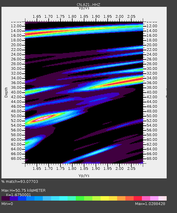
| Estimated Moho Depth: |
50.75 km |
| Estimated Crust Vp/Vs: |
1.68 |
| Assumed Crust Vp: |
6.419 km/s |
| Estimated Crust Vs: |
3.832 km/s |
| Estimated Crust Poisson's Ratio: |
0.22 |
|
| Radial Match: |
93.07703 % |
| Radial Bump: |
400 |
| Transverse Match: |
79.25738 % |
| Transverse Bump: |
400 |
| SOD ConfigId: |
13570011 |
| Insert Time: |
2019-04-28 23:11:51.171 +0000 |
| GWidth: |
2.5 |
| Max Bumps: |
400 |
| Tol: |
0.001 |
|

Signal To Noise
| Channel | StoN | STA | LTA |
| CN:A21: :HHZ:20171008T22:44:33.009988Z | 15.875488 | 4.1999297E-6 | 2.6455436E-7 |
| CN:A21: :HHN:20171008T22:44:33.009988Z | 9.336814 | 1.4261192E-6 | 1.5274152E-7 |
| CN:A21: :HHE:20171008T22:44:33.009988Z | 5.574473 | 1.3264035E-6 | 2.3794242E-7 |
| Arrivals |
| Ps | 5.6 SECOND |
| PpPs | 20 SECOND |
| PsPs/PpSs | 26 SECOND |


