You are here: Home > Network List > EI - Irish National Seismic Network (INSN) Stations List
> Station VAL Valentia > Earthquake Result Viewer
VAL Valentia - Earthquake Result Viewer
| Earthquake location: |
Rat Islands, Aleutian Islands |
| Earthquake latitude/longitude: |
52.4/176.8 |
| Earthquake time(UTC): |
2017/10/08 (281) 22:34:33 GMT |
| Earthquake Depth: |
112 km |
| Earthquake Magnitude: |
6.6 mww |
| Earthquake Catalog/Contributor: |
NEIC PDE/us |
|
| Network: |
EI Irish National Seismic Network (INSN) |
| Station: |
VAL Valentia |
| Lat/Lon: |
51.94 N/10.24 W |
| Elevation: |
14 m |
|
| Distance: |
75.8 deg |
| Az: |
4.496 deg |
| Baz: |
355.555 deg |
| Ray Param: |
0.051146828 |
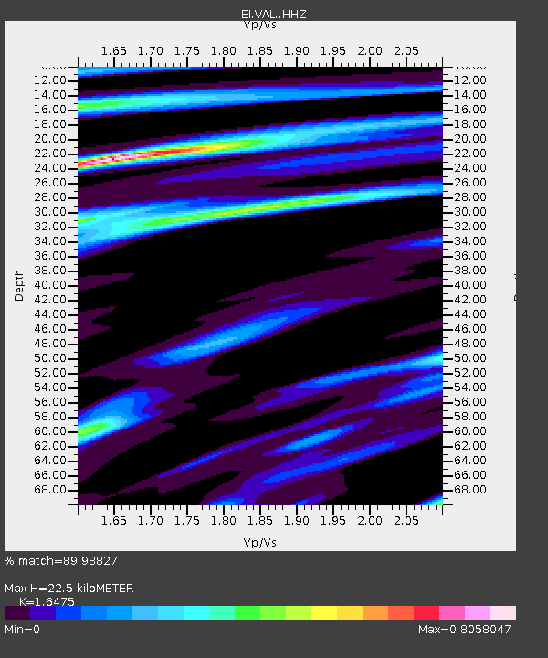
| Estimated Moho Depth: |
22.5 km |
| Estimated Crust Vp/Vs: |
1.65 |
| Assumed Crust Vp: |
6.24 km/s |
| Estimated Crust Vs: |
3.788 km/s |
| Estimated Crust Poisson's Ratio: |
0.21 |
|
| Radial Match: |
89.98827 % |
| Radial Bump: |
308 |
| Transverse Match: |
85.50734 % |
| Transverse Bump: |
400 |
| SOD ConfigId: |
13570011 |
| Insert Time: |
2019-04-28 23:12:45.983 +0000 |
| GWidth: |
2.5 |
| Max Bumps: |
400 |
| Tol: |
0.001 |
|

Signal To Noise
| Channel | StoN | STA | LTA |
| EI:VAL: :HHZ:20171008T22:45:36.829995Z | 9.694243 | 2.6879543E-6 | 2.7727322E-7 |
| EI:VAL: :HHN:20171008T22:45:36.829995Z | 3.4253101 | 8.410289E-7 | 2.4553364E-7 |
| EI:VAL: :HHE:20171008T22:45:36.829995Z | 1.3066812 | 2.330026E-7 | 1.7831634E-7 |
| Arrivals |
| Ps | 2.4 SECOND |
| PpPs | 9.2 SECOND |
| PsPs/PpSs | 12 SECOND |


