You are here: Home > Network List > UU - University of Utah Regional Network Stations List
> Station FORU South Mineral Mountains, UT, USA > Earthquake Result Viewer
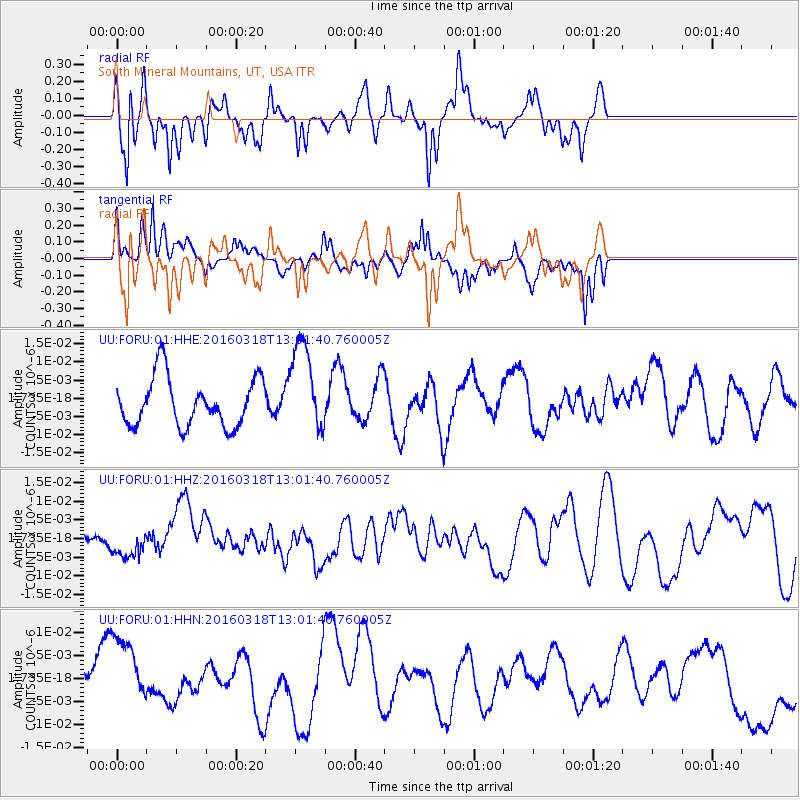
FORU South Mineral Mountains, UT, USA - Earthquake Result Viewer
*The percent match for this event was below the threshold and hence no stack was calculated.
| Earthquake location: |
Santa Cruz Islands |
| Earthquake latitude/longitude: |
-12.5/166.5 |
| Earthquake time(UTC): |
2016/03/18 (078) 12:49:14 GMT |
| Earthquake Depth: |
42 km |
| Earthquake Magnitude: |
5.5 MWB |
| Earthquake Catalog/Contributor: |
NEIC PDE/NEIC COMCAT |
|
| Network: |
UU University of Utah Regional Network |
| Station: |
FORU South Mineral Mountains, UT, USA |
| Lat/Lon: |
38.46 N/112.86 W |
| Elevation: |
1840 m |
|
| Distance: |
90.5 deg |
| Az: |
50.767 deg |
| Baz: |
254.491 deg |
| Ray Param: |
$rayparam |
*The percent match for this event was below the threshold and hence was not used in the summary stack. |
|
| Radial Match: |
65.39964 % |
| Radial Bump: |
363 |
| Transverse Match: |
53.151512 % |
| Transverse Bump: |
353 |
| SOD ConfigId: |
1464191 |
| Insert Time: |
2016-04-01 13:22:39.924 +0000 |
| GWidth: |
2.5 |
| Max Bumps: |
400 |
| Tol: |
0.001 |
|
Signal To Noise
| Channel | StoN | STA | LTA |
| UU:FORU:01:HHZ:20160318T13:01:40.760005Z | 0.71866 | 3.4458378E-9 | 4.7948094E-9 |
| UU:FORU:01:HHN:20160318T13:01:40.760005Z | 2.0512118 | 8.183587E-9 | 3.989635E-9 |
| UU:FORU:01:HHE:20160318T13:01:40.760005Z | 1.8884628 | 1.2568641E-8 | 6.655488E-9 |
| Arrivals |
| Ps | |
| PpPs | |
| PsPs/PpSs | |


