You are here: Home > Network List > GB - Great Britain Seismograph Network Stations List
> Station HMNX HERSMONCEAUX, ENGLAND > Earthquake Result Viewer
HMNX HERSMONCEAUX, ENGLAND - Earthquake Result Viewer
| Earthquake location: |
Rat Islands, Aleutian Islands |
| Earthquake latitude/longitude: |
52.4/176.8 |
| Earthquake time(UTC): |
2017/10/08 (281) 22:34:33 GMT |
| Earthquake Depth: |
112 km |
| Earthquake Magnitude: |
6.6 mww |
| Earthquake Catalog/Contributor: |
NEIC PDE/us |
|
| Network: |
GB Great Britain Seismograph Network |
| Station: |
HMNX HERSMONCEAUX, ENGLAND |
| Lat/Lon: |
50.87 N/0.34 E |
| Elevation: |
26 m |
|
| Distance: |
77.0 deg |
| Az: |
357.706 deg |
| Baz: |
2.215 deg |
| Ray Param: |
0.050346274 |
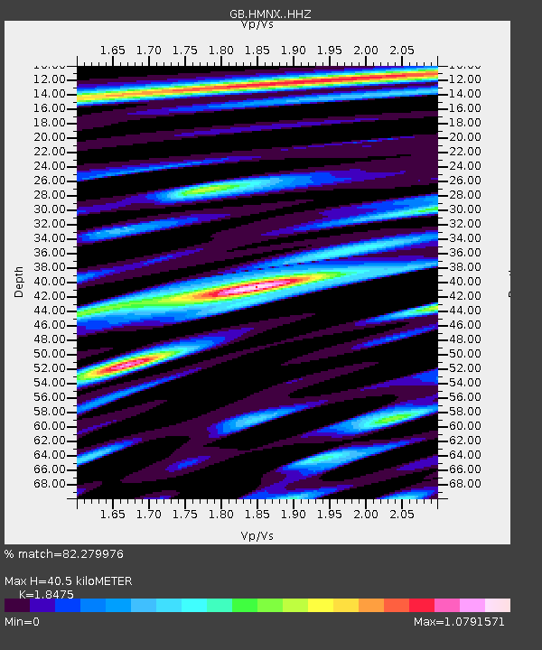
| Estimated Moho Depth: |
40.5 km |
| Estimated Crust Vp/Vs: |
1.85 |
| Assumed Crust Vp: |
6.207 km/s |
| Estimated Crust Vs: |
3.36 km/s |
| Estimated Crust Poisson's Ratio: |
0.29 |
|
| Radial Match: |
82.279976 % |
| Radial Bump: |
400 |
| Transverse Match: |
71.26733 % |
| Transverse Bump: |
400 |
| SOD ConfigId: |
13570011 |
| Insert Time: |
2019-04-28 23:13:00.771 +0000 |
| GWidth: |
2.5 |
| Max Bumps: |
400 |
| Tol: |
0.001 |
|

Signal To Noise
| Channel | StoN | STA | LTA |
| GB:HMNX: :HHZ:20171008T22:45:43.579995Z | 5.511612 | 2.6354048E-6 | 4.78155E-7 |
| GB:HMNX: :HHN:20171008T22:45:43.579995Z | 2.3724866 | 1.0469042E-6 | 4.4126878E-7 |
| GB:HMNX: :HHE:20171008T22:45:43.579995Z | 1.0183318 | 4.772244E-7 | 4.6863352E-7 |
| Arrivals |
| Ps | 5.7 SECOND |
| PpPs | 18 SECOND |
| PsPs/PpSs | 24 SECOND |


