You are here: Home > Network List > TA - USArray Transportable Network (new EarthScope stations) Stations List
> Station G14A Jackson, MT, USA > Earthquake Result Viewer
G14A Jackson, MT, USA - Earthquake Result Viewer
| Earthquake location: |
Kuril Islands |
| Earthquake latitude/longitude: |
46.0/151.4 |
| Earthquake time(UTC): |
2009/04/18 (108) 19:17:58 GMT |
| Earthquake Depth: |
35 km |
| Earthquake Magnitude: |
6.3 MB, 6.3 MS, 6.6 MW, 6.4 MW |
| Earthquake Catalog/Contributor: |
WHDF/NEIC |
|
| Network: |
TA USArray Transportable Network (new EarthScope stations) |
| Station: |
G14A Jackson, MT, USA |
| Lat/Lon: |
45.24 N/113.46 W |
| Elevation: |
2140 m |
|
| Distance: |
62.4 deg |
| Az: |
52.581 deg |
| Baz: |
308.425 deg |
| Ray Param: |
0.060208127 |
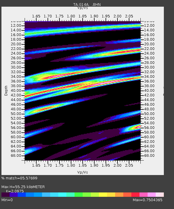
| Estimated Moho Depth: |
55.25 km |
| Estimated Crust Vp/Vs: |
2.10 |
| Assumed Crust Vp: |
6.577 km/s |
| Estimated Crust Vs: |
3.136 km/s |
| Estimated Crust Poisson's Ratio: |
0.35 |
|
| Radial Match: |
85.57699 % |
| Radial Bump: |
400 |
| Transverse Match: |
74.299576 % |
| Transverse Bump: |
400 |
| SOD ConfigId: |
2658 |
| Insert Time: |
2010-03-06 05:07:38.299 +0000 |
| GWidth: |
2.5 |
| Max Bumps: |
400 |
| Tol: |
0.001 |
|
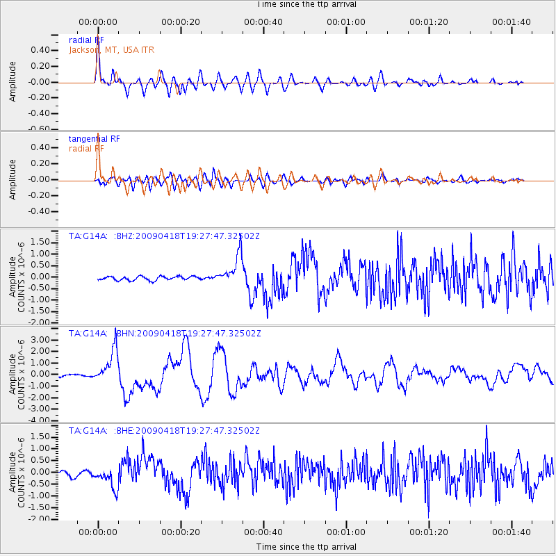
Signal To Noise
| Channel | StoN | STA | LTA |
| TA:G14A: :BHN:20090418T19:27:47.32502Z | 15.124486 | 1.5303034E-6 | 1.0118052E-7 |
| TA:G14A: :BHE:20090418T19:27:47.32502Z | 4.658119 | 4.9697366E-7 | 1.06689775E-7 |
| TA:G14A: :BHZ:20090418T19:27:47.32502Z | 8.366654 | 7.028005E-7 | 8.4000185E-8 |
| Arrivals |
| Ps | 9.6 SECOND |
| PpPs | 25 SECOND |
| PsPs/PpSs | 35 SECOND |


